
Topografische Karte Salado
Interaktive Karte
Klicken Sie auf die Karte, um die Höhe anzuzeigen.
Über diese Karte
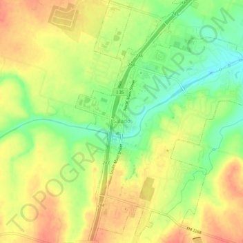
Name: Topografische Karte Salado, Höhe, Relief.
Ort: Salado, Bell County, Texas, 76571, United States (30.92575 -97.54655 30.96774 -97.50195)
Durchschnittliche Höhe: 196 m
Minimale Höhe: 166 m
Maximale Höhe: 219 m
Andere topografische Karten
Klicken Sie auf eine Karte, um ihre Topografie, ihre Höhe und ihr Relief anzuzeigen.
Belton
United States > Texas > Bell County
Belton, Bell County, Texas, United States
Durchschnittliche Höhe: 179 m
Belton
United States > Texas > Bell County > Belton > Belton
Belton, Bell County, Texas, 76513, United States
Durchschnittliche Höhe: 176 m
Harker Heights
United States > Texas > Bell County
Harker Heights, Bell County, Texas, 76548, United States
Durchschnittliche Höhe: 235 m
Little River-Academy
United States > Texas > Bell County > Little River-Academy
Little River-Academy, Bell County, Texas, 76554, United States
Durchschnittliche Höhe: 152 m
Meeks
United States > Texas > Bell County
Meeks, Bell County, Texas, 76519, United States
Durchschnittliche Höhe: 134 m
Morgans Point Resort
United States > Texas > Bell County > Morgans Point Resort
Morgans Point Resort, Bell County, Texas, United States
Durchschnittliche Höhe: 201 m
Rogers
United States > Texas > Bell County > Rogers
Rogers, Bell County, Texas, United States
Durchschnittliche Höhe: 159 m
Killeen
United States > Texas > Bell County > Killeen
Killeen, Bell County, Texas, 76541, United States
Durchschnittliche Höhe: 257 m
Killeen
United States > Texas > Bell County
Killeen, Bell County, Texas, United States
Durchschnittliche Höhe: 266 m
Temple
United States > Texas > Bell County
Temple, Bell County, Texas, United States
Durchschnittliche Höhe: 186 m
Belton
United States > Texas > Bell County
Belton, Bell County, Texas, United States
Durchschnittliche Höhe: 179 m