
Spenden
Rüste dich für dein nächstes Abenteuer:
Als Amazon-Partner verdient diese Seite an qualifizierten Käufen, ohne dass Ihnen zusätzliche Kosten entstehen.
Topografische Karte Majayjay
Klicken Sie auf die Karte, um die Höhe anzuzeigen.
Spenden
Rüste dich für dein nächstes Abenteuer:
Als Amazon-Partner verdient diese Seite an qualifizierten Käufen, ohne dass Ihnen zusätzliche Kosten entstehen.
Majayjay
Majayjay is geographically a landlocked area situated in the southernmost part of the province of Laguna. It nestles at the foot of the mystical Mt. Banahaw, and due to its higher altitude at some 2,700+ ft above sea level, the town makes for a good vacation destination during the summer season in the Philippines. It was once branded as the Summer Capital of the Philippines 300–400 years ago during the Spanish era when most of the huge names in the Spanish colonial Philippines visited this humble place. Other sights along the streets are the remnants of the said era for Spanish-inspired houses still stand at random key locations mostly in the town square. Famous and affluent families then still have their ancestral houses maintained.
Spenden
Rüste dich für dein nächstes Abenteuer:
Als Amazon-Partner verdient diese Seite an qualifizierten Käufen, ohne dass Ihnen zusätzliche Kosten entstehen.
Über diese Karte
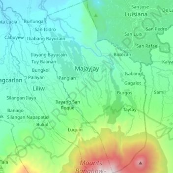
Name: Topografische Karte Majayjay, Höhe, Relief.
Ort: Majayjay, Laguna, Calabarzon, Philippines (14.06786 121.43648 14.19532 121.51789)
Durchschnittliche Höhe: 488 m
Minimale Höhe: 43 m
Maximale Höhe: 2’136 m
Spenden
Rüste dich für dein nächstes Abenteuer:
Als Amazon-Partner verdient diese Seite an qualifizierten Käufen, ohne dass Ihnen zusätzliche Kosten entstehen.
Andere topografische Karten
Klicken Sie auf eine Karte, um ihre Topografie, ihre Höhe und ihr Relief anzuzeigen.
Mount Banahaw and San Cristobal Protected Landscape
Philippines > Laguna > Liliw
Durchschnittliche Höhe: 592 m
Spenden
Rüste dich für dein nächstes Abenteuer:
Als Amazon-Partner verdient diese Seite an qualifizierten Käufen, ohne dass Ihnen zusätzliche Kosten entstehen.
Spenden
Rüste dich für dein nächstes Abenteuer:
Als Amazon-Partner verdient diese Seite an qualifizierten Käufen, ohne dass Ihnen zusätzliche Kosten entstehen.
Spenden
Rüste dich für dein nächstes Abenteuer:
Als Amazon-Partner verdient diese Seite an qualifizierten Käufen, ohne dass Ihnen zusätzliche Kosten entstehen.
Spenden
Rüste dich für dein nächstes Abenteuer:
Als Amazon-Partner verdient diese Seite an qualifizierten Käufen, ohne dass Ihnen zusätzliche Kosten entstehen.
Spenden
Rüste dich für dein nächstes Abenteuer:
Als Amazon-Partner verdient diese Seite an qualifizierten Käufen, ohne dass Ihnen zusätzliche Kosten entstehen.