
Topografische Karte Rangeley
Interaktive Karte
Klicken Sie auf die Karte, um die Höhe anzuzeigen.
Über diese Karte
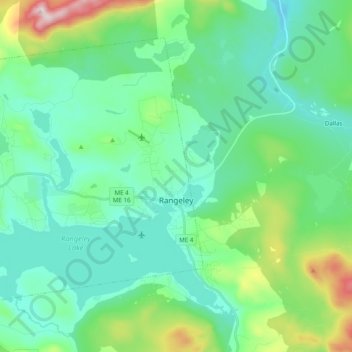
Name: Topografische Karte Rangeley, Höhe, Relief.
Ort: Rangeley, Franklin County, Maine, United States (44.92166 -70.82363 45.03064 -70.62823)
Durchschnittliche Höhe: 548 m
Minimale Höhe: 421 m
Maximale Höhe: 1’021 m
This climatic region has large seasonal temperature differences, with warm (and often humid) summers and cold (sometimes severely cold) winters. According to the Köppen Climate Classification system, Rangeley has a humid continental climate, abbreviated "Dfb" on climate maps. Similar to the rest of New England, snowfall is high in Rangeley, but due to the cold mean temperatures in winter, it remains on the ground for several months. Summer temperatures are moderated by the elevation and are thus cooler than other nearby towns.
Andere topografische Karten
Klicken Sie auf eine Karte, um ihre Topografie, ihre Höhe und ihr Relief anzuzeigen.
Madrid Township
United States > Maine > Franklin County
Madrid Township, Franklin County, Maine, United States
Durchschnittliche Höhe: 522 m
Stratton
United States > Maine > Franklin County
Stratton, Franklin County, Maine, 04982, United States
Durchschnittliche Höhe: 374 m
Coburn Gore
United States > Maine > Franklin County
Coburn Gore, Franklin County, Maine, United States
Durchschnittliche Höhe: 467 m
Strong
United States > Maine > Franklin County
Strong, Franklin County, Maine, 04983, United States
Durchschnittliche Höhe: 260 m
Farmington
United States > Maine > Franklin County
Farmington, Franklin County, Maine, United States
Durchschnittliche Höhe: 192 m
New Vineyard
United States > Maine > Franklin County
New Vineyard, Franklin County, Maine, 04956, United States
Durchschnittliche Höhe: 251 m
Eustis
United States > Maine > Franklin County
Eustis, Franklin County, Maine, United States
Durchschnittliche Höhe: 413 m
Phillips
United States > Maine > Franklin County
Phillips, Franklin County, Maine, 04966, United States
Durchschnittliche Höhe: 322 m