
Topografische Karte Madrid Township
Interaktive Karte
Klicken Sie auf die Karte, um die Höhe anzuzeigen.
Über diese Karte
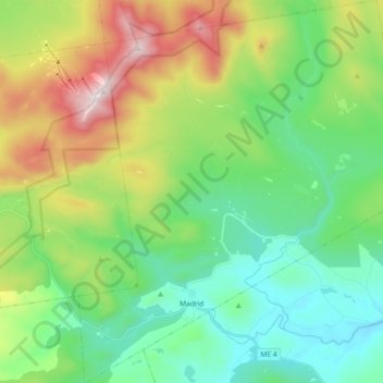
Name: Topografische Karte Madrid Township, Höhe, Relief.
Ort: Madrid Township, Franklin County, Maine, United States (44.83732 -70.51628 44.96741 -70.34894)
Durchschnittliche Höhe: 522 m
Minimale Höhe: 199 m
Maximale Höhe: 1’246 m
Although Madrid's northern topography is mountainous, other parts suited cultivation. In 1837, when the population was 351, farms harvested 3,387 bushels of wheat.
Andere topografische Karten
Klicken Sie auf eine Karte, um ihre Topografie, ihre Höhe und ihr Relief anzuzeigen.
Stratton
United States > Maine > Franklin County
Stratton, Franklin County, Maine, 04982, United States
Durchschnittliche Höhe: 374 m
Coburn Gore
United States > Maine > Franklin County
Coburn Gore, Franklin County, Maine, United States
Durchschnittliche Höhe: 467 m
Strong
United States > Maine > Franklin County
Strong, Franklin County, Maine, 04983, United States
Durchschnittliche Höhe: 260 m
Farmington
United States > Maine > Franklin County
Farmington, Franklin County, Maine, United States
Durchschnittliche Höhe: 192 m
New Vineyard
United States > Maine > Franklin County
New Vineyard, Franklin County, Maine, 04956, United States
Durchschnittliche Höhe: 251 m
Eustis
United States > Maine > Franklin County
Eustis, Franklin County, Maine, United States
Durchschnittliche Höhe: 413 m
Phillips
United States > Maine > Franklin County
Phillips, Franklin County, Maine, 04966, United States
Durchschnittliche Höhe: 322 m
Rangeley
United States > Maine > Franklin County
Rangeley, Franklin County, Maine, United States
Durchschnittliche Höhe: 548 m