
Topografische Karte Montottone
Interaktive Karte
Klicken Sie auf die Karte, um die Höhe anzuzeigen.
Über diese Karte
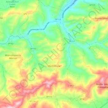
Name: Topografische Karte Montottone, Höhe, Relief.
Ort: Montottone, Fermo, Marche, 63843, Italy (43.03645 13.56073 43.10233 13.60770)
Durchschnittliche Höhe: 220 m
Minimale Höhe: 84 m
Maximale Höhe: 422 m
Andere topografische Karten
Klicken Sie auf eine Karte, um ihre Topografie, ihre Höhe und ihr Relief anzuzeigen.
Porto San Giorgio
Porto San Giorgio, Fermo, Marche, 63822, Italy
Durchschnittliche Höhe: 33 m
Rovitolo
Italy > Marche > Fermo > Montefortino > Col Martese
Rovitolo, Col Martese, Montefortino, Fermo, Marche, 63858, Italy
Durchschnittliche Höhe: 586 m