
Topografische Karte Meron
Interaktive Karte
Klicken Sie auf die Karte, um die Höhe anzuzeigen.
Über diese Karte
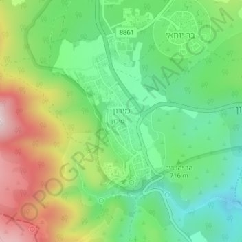
Name: Topografische Karte Meron, Höhe, Relief.
Durchschnittliche Höhe: 735 m
Minimale Höhe: 571 m
Maximale Höhe: 1’004 m
Meron is noted for its mountainous terrain and valleys. Among the local attractions are the Meron Vineyards. Meron is conducive to growing grapes for wine as a result of its 600-meter altitude and chalky soil. The vineyard was first planted in 2000 and is part of the Galil Mountain Winery, headquartered in nearby Kibbutz Yiron.
Andere topografische Karten
Klicken Sie auf eine Karte, um ihre Topografie, ihre Höhe und ihr Relief anzuzeigen.
Livnim
Israel > North District > Merom HaGalil Regional Council
Livnim, Merom HaGalil Regional Council, Safed Subdistrict, North District, Israel
Durchschnittliche Höhe: -83 m
Amirim
Israel > North District > Merom HaGalil Regional Council
Amirim, Merom HaGalil Regional Council, Safed Subdistrict, North District, Israel
Durchschnittliche Höhe: 512 m
Avivim
Israel > North District > Merom HaGalil Regional Council > Avivim
Avivim, Merom HaGalil Regional Council, Safed Subdistrict, North District, Israel
Durchschnittliche Höhe: 704 m
Mount Meron
Israel > North District > Merom HaGalil Regional Council
Mount Meron, Merom HaGalil Regional Council, Safed Subdistrict, North District, Israel
Durchschnittliche Höhe: 943 m