
Topografische Karte Mount Meron
Interaktive Karte
Klicken Sie auf die Karte, um die Höhe anzuzeigen.
Über diese Karte
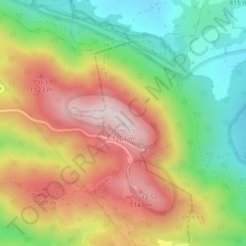
Name: Topografische Karte Mount Meron, Höhe, Relief.
Durchschnittliche Höhe: 943 m
Minimale Höhe: 717 m
Maximale Höhe: 1’194 m
Andere topografische Karten
Klicken Sie auf eine Karte, um ihre Topografie, ihre Höhe und ihr Relief anzuzeigen.
Livnim
Israel > North District > Merom HaGalil Regional Council
Livnim, Merom HaGalil Regional Council, Safed Subdistrict, North District, Israel
Durchschnittliche Höhe: -83 m
Meron
Israel > North District > Merom HaGalil Regional Council
Meron, Merom HaGalil Regional Council, Safed Subdistrict, North District, Israel
Durchschnittliche Höhe: 735 m
Amirim
Israel > North District > Merom HaGalil Regional Council
Amirim, Merom HaGalil Regional Council, Safed Subdistrict, North District, Israel
Durchschnittliche Höhe: 512 m
Avivim
Israel > North District > Merom HaGalil Regional Council > Avivim
Avivim, Merom HaGalil Regional Council, Safed Subdistrict, North District, Israel
Durchschnittliche Höhe: 704 m