
Topografische Karte Nebo
Interaktive Karte
Klicken Sie auf die Karte, um die Höhe anzuzeigen.
Über diese Karte
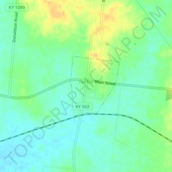
Name: Topografische Karte Nebo, Höhe, Relief.
Ort: Nebo, Hopkins County, Kentucky, United States (37.37823 -87.64589 37.38757 -87.63627)
Durchschnittliche Höhe: 122 m
Minimale Höhe: 111 m
Maximale Höhe: 139 m
Andere topografische Karten
Klicken Sie auf eine Karte, um ihre Topografie, ihre Höhe und ihr Relief anzuzeigen.
Hanson
United States > Kentucky > Hopkins County
Hanson, Hopkins County, Kentucky, 42413, United States
Durchschnittliche Höhe: 132 m
Richland
United States > Kentucky > Hopkins County
Richland, Hopkins County, Kentucky, United States
Durchschnittliche Höhe: 130 m
Saint Charles
United States > Kentucky > Hopkins County > St. Charles
Saint Charles, St. Charles, Hopkins County, Kentucky, 42453, United States
Durchschnittliche Höhe: 153 m
Nortonville
United States > Kentucky > Hopkins County
Nortonville, Hopkins County, Kentucky, 42442, United States
Durchschnittliche Höhe: 133 m