
Topografische Karte Nortonville
Interaktive Karte
Klicken Sie auf die Karte, um die Höhe anzuzeigen.
Über diese Karte
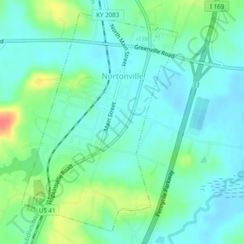
Name: Topografische Karte Nortonville, Höhe, Relief.
Ort: Nortonville, Hopkins County, Kentucky, 42442, United States (37.17368 -87.46679 37.19792 -87.44511)
Durchschnittliche Höhe: 133 m
Minimale Höhe: 118 m
Maximale Höhe: 174 m
Andere topografische Karten
Klicken Sie auf eine Karte, um ihre Topografie, ihre Höhe und ihr Relief anzuzeigen.
Hanson
United States > Kentucky > Hopkins County
Hanson, Hopkins County, Kentucky, 42413, United States
Durchschnittliche Höhe: 132 m
Richland
United States > Kentucky > Hopkins County
Richland, Hopkins County, Kentucky, United States
Durchschnittliche Höhe: 130 m
Nebo
United States > Kentucky > Hopkins County
Nebo, Hopkins County, Kentucky, United States
Durchschnittliche Höhe: 122 m
Saint Charles
United States > Kentucky > Hopkins County > St. Charles
Saint Charles, St. Charles, Hopkins County, Kentucky, 42453, United States
Durchschnittliche Höhe: 153 m