
Topografische Karte Jacksonville
Interaktive Karte
Klicken Sie auf die Karte, um die Höhe anzuzeigen.
Über diese Karte
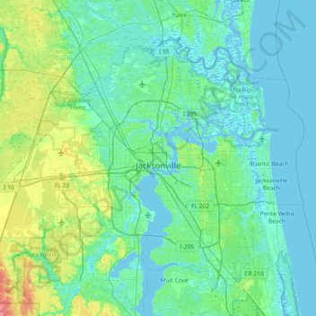
Name: Topografische Karte Jacksonville, Höhe, Relief.
Ort: Jacksonville, Duval County, Florida, United States (30.10375 -82.04939 30.58621 -81.31671)
Durchschnittliche Höhe: 10 m
Minimale Höhe: -4 m
Maximale Höhe: 65 m
Andere topografische Karten
Klicken Sie auf eine Karte, um ihre Topografie, ihre Höhe und ihr Relief anzuzeigen.
Atlantic Beach
United States > Florida > Duval County
Atlantic Beach, Duval County, Florida, 32233, United States
Durchschnittliche Höhe: 2 m
Pineland Gardens
United States > Florida > Duval County > Jacksonville
Pineland Gardens, Jacksonville, Duval County, Florida, 32216, United States
Durchschnittliche Höhe: 9 m
Jacksonville
United States > Florida > Duval County > Jacksonville
Jacksonville, Duval County, Florida, 32202, United States
Durchschnittliche Höhe: 9 m