Geolokalisieren

Topografische Karte County Roscommon

Klicken Sie auf die Karte, um die Höhe anzuzeigen.

Über diese Karte

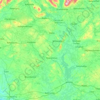
Name: Topografische Karte County Roscommon, Höhe, Relief.

Ort: County Roscommon, Connacht, Ireland (53.27133 -8.82368 54.12524 -7.87588)

Durchschnittliche Höhe: 77 m

Minimale Höhe: 4 m

Maximale Höhe: 581 m

Andere topografische Karten

Klicken Sie auf eine Karte, um ihre Topografie, ihre Höhe und ihr Relief anzuzeigen.

Cork

Ireland > County Cork > Cork

Durchschnittliche Höhe: 94 m

Galway City

Ireland > Galway City

Durchschnittliche Höhe: 26 m

Maghera Strand

Ireland

Durchschnittliche Höhe: 37 m

Malin Head

Ireland > County Donegal

Durchschnittliche Höhe: 4 m

Cromane

Ireland

Durchschnittliche Höhe: 3 m

Seefin

Ireland > County Waterford

Durchschnittliche Höhe: 498 m

Spike Island

Ireland > County Cork

Durchschnittliche Höhe: 2 m

Galtymore

Ireland > County Limerick > The Municipal District of Cappamore — Kilmallock

Galtymore or Galteemore (Irish: Cnoc Mór na nGaibhlte, meaning 'big hill of the Galtees') is a mountain in the province of Munster, Ireland. At 917.9 metres (3,011 ft 6 in), it is one of Ireland's highest mountains, being the 12th-highest on the Arderin list, and 14th-highest on the Vandeleur-Lynam list.…

Durchschnittliche Höhe: 594 m

Bartlemy

Ireland > County Cork

Durchschnittliche Höhe: 98 m

Bohermeen

Ireland > County Meath

Durchschnittliche Höhe: 74 m

Mount Brandon

Ireland > County Kerry

Durchschnittliche Höhe: 572 m

Letterkenny

Ireland > County Donegal > Letterkenny

Durchschnittliche Höhe: 93 m

River Shannon

Ireland

Durchschnittliche Höhe: 39 m

Blackrock

Ireland > County Louth

Durchschnittliche Höhe: 5 m

Lough Nagreany

Ireland > County Donegal > Letterkenny

Durchschnittliche Höhe: 36 m

Cornaseer

Ireland > County Cavan

Durchschnittliche Höhe: 113 m

Knockavilla

Ireland > County Cork

Durchschnittliche Höhe: 85 m

Moneystown

Ireland > County Wicklow

Durchschnittliche Höhe: 223 m

Ballybrown

Ireland > County Limerick > Limerick

Durchschnittliche Höhe: 9 m

Geevagh

Ireland > County Sligo

Durchschnittliche Höhe: 92 m

Annayalla

Ireland > County Monaghan

Durchschnittliche Höhe: 123 m

Doolin Cave

Ireland > County Clare

Durchschnittliche Höhe: 87 m

Inis Meáin

Ireland > County Donegal

Durchschnittliche Höhe: 1 m

Mizen Head

Ireland > County Cork

Durchschnittliche Höhe: 25 m

Boyne

Ireland > County Meath

Durchschnittliche Höhe: 29 m

Mangerton

Ireland > County Kerry

Mangerton Mountain's height and topographic prominence, qualifies it to meet the British Isles Marilyn classification, as well as the Arderin, Simm and Hewitt classifications. Mangerton Mountain ranks as the 10th-highest mountain in Ireland on the MountainViews Online Database, 100 Highest Irish Mountains,…

Durchschnittliche Höhe: 657 m

Killiney Hill

Ireland > County Dublin > Killiney

Durchschnittliche Höhe: 40 m

Nohoval

Ireland > County Cork

Durchschnittliche Höhe: 56 m

Sneem

Ireland > County Kerry > Scrahanagaur

Durchschnittliche Höhe: 27 m

Poolbeg Lighthouse

Ireland > County Dublin > Dublin

Durchschnittliche Höhe: 0 m

Ardclough

Ireland > County Kildare

Durchschnittliche Höhe: 76 m

Ballinagh

Ireland > County Cavan > Bellananagh

Durchschnittliche Höhe: 94 m

Blacklion

Ireland > County Cavan

Durchschnittliche Höhe: 92 m

Knockmore

Ireland > County Mayo

Durchschnittliche Höhe: 108 m

Knockaderry

Ireland > County Waterford > Coolnasmear

Durchschnittliche Höhe: 147 m

Beaumont Park

Ireland > County Cork > Cork

Durchschnittliche Höhe: 12 m

Stonyford

Ireland > County Kilkenny

Durchschnittliche Höhe: 64 m

Ward Cross

Ireland > County Dublin

Durchschnittliche Höhe: 75 m

Clare

Ireland > County Galway

Durchschnittliche Höhe: 30 m

Hugginstown

Ireland > County Kilkenny

Durchschnittliche Höhe: 129 m

Watergrasshill

Ireland > County Cork

According to A Topographical Dictionary of Ireland, published by Samuel Lewis in 1837, Watergrasshill then had a population of 533 people.

Durchschnittliche Höhe: 164 m

Cashlaundrumlahan

Ireland > County Galway

Durchschnittliche Höhe: 310 m

Bettystown

Ireland > County Meath

Durchschnittliche Höhe: 6 m

Beenkeragh

Ireland > County Kerry

Beenkeragh is the second-highest peak in Ireland, on both the Arderin and Vandeleur-Lynam lists. It is the 179th-highest mountain in Britain and Ireland on the Simm classification. Beenkeragh is regarded by the Scottish Mountaineering Club ("SMC") as one of 34 Furths, which is a mountain above 3,000 ft (914 m)…

Durchschnittliche Höhe: 654 m

Caher

Ireland > County Kerry

Caher is the 200th–highest mountain in Britain and Ireland on the Simm classification. Caher is regarded by the Scottish Mountaineering Club ("SMC") as one of 34 Furths, which is a mountain above 3,000 ft (914.4 m) in elevation, and meets the other SMC criteria for a Munro (e.g. "sufficient separation"), but…

Durchschnittliche Höhe: 617 m

Knocknapeasta

Ireland > County Kerry

It is the 231st-highest mountain in Britain and Ireland on the Simm classification. Cnoc na Péiste is regarded by the Scottish Mountaineering Club ("SMC") as one of 34 Furths, which is a mountain above 3,000 ft (914.4 m) in elevation, and meets the other SMC criteria for a Munro (e.g. "sufficient…

Durchschnittliche Höhe: 579 m

Lugnaquilla

Ireland > County Wicklow

Lugnaquilla is the 432nd-highest and 21st most prominent mountain in Britain and Ireland, on the Simms classification. It is regarded by the Scottish Mountaineering Club (SMC) as one of 34 Furths, which is a mountain above 3,000 ft (914 m) in elevation, and meets the other SMC criteria for a Munro (e.g.…

Durchschnittliche Höhe: 696 m

Baurtregaum

Ireland > County Kerry

Durchschnittliche Höhe: 606 m

Caherconree

Ireland > County Kerry

Durchschnittliche Höhe: 536 m

Mweelrea

Ireland > County Mayo

Durchschnittliche Höhe: 422 m

Errigal

Ireland > County Donegal

Durchschnittliche Höhe: 295 m

Slieve League

Ireland > County Donegal

Durchschnittliche Höhe: 233 m

Devil's Bit Mountain

Ireland > County Tipperary

Durchschnittliche Höhe: 291 m

Slieve Foye

Ireland > County Louth

Durchschnittliche Höhe: 287 m

Blackstairs Mountain

Ireland > County Carlow

Durchschnittliche Höhe: 429 m

Silvermine Mountains E Top

Ireland > County Tipperary

Durchschnittliche Höhe: 294 m

River Lee (North Channel)

Ireland > County Cork > Cork

Durchschnittliche Höhe: 49 m

Clare

Ireland > County Galway

Durchschnittliche Höhe: 34 m

Feale

Ireland > County Kerry

Durchschnittliche Höhe: 47 m

Derg

Ireland > County Donegal

Durchschnittliche Höhe: 166 m

Garavogue

Ireland > County Sligo

Durchschnittliche Höhe: 20 m

Camlin

Ireland > County Longford > Cloonfin

Durchschnittliche Höhe: 66 m

Doo Lough

Ireland > County Kerry

Durchschnittliche Höhe: 20 m

Lough Dan

Ireland > County Wicklow

Durchschnittliche Höhe: 309 m

Lough Tay

Ireland > County Wicklow

Durchschnittliche Höhe: 395 m

Tory Island

Ireland > County Donegal

Durchschnittliche Höhe: 3 m

Lettermore

Ireland > County Cavan

Durchschnittliche Höhe: 90 m

Lambay Island

Ireland > County Dublin

Lambay Island is the largest island off the east coast of Ireland. It covers about 2.5 km2 (0.97 sq mi). The highest point – a hill known as Knockbane – rises to 126 m (413 ft). The island's high ground lies to the east and aside from Knockbane includes Heath Hill and Tinian Hill, and in the extreme…

Durchschnittliche Höhe: 14 m

Great Skellig

Ireland > County Kerry

The island is of special interest to archaeologists, as the monastic settlement is in unusually good condition. The monastery on the northern peak is situated at an elevation of 170 to 180 m (550 to 600 ft), Christ's Saddle at 129 m (422 ft), and the flagstaff area are 37 m (120 ft) above sea level. The…

Durchschnittliche Höhe: 1 m

Little Skellig

Ireland > County Kerry

Durchschnittliche Höhe: 0 m

Inishshark

Ireland > County Galway

Durchschnittliche Höhe: 11 m

Inishbiggle

Ireland > County Mayo

Durchschnittliche Höhe: 3 m

Doneraile Wildlife Park

Ireland > County Cork

Durchschnittliche Höhe: 87 m

St Anne's Park

Ireland > County Dublin > Dublin

Durchschnittliche Höhe: 13 m

Derrynane National Historic Park

Ireland > County Kerry

Durchschnittliche Höhe: 51 m

Rathfarnham

Ireland > County Dublin

Durchschnittliche Höhe: 56 m

Benbulbin

Ireland > County Sligo

Durchschnittliche Höhe: 257 m

Gusserane

Ireland > County Wexford > New Ross Municipal District

Durchschnittliche Höhe: 51 m

Bealad Cross Roads

Ireland > County Cork

Durchschnittliche Höhe: 94 m

Timahoe

Ireland > County Laois

Durchschnittliche Höhe: 146 m

Kilpedder

Ireland > County Wicklow

Durchschnittliche Höhe: 99 m

Brandon Hill

Ireland > County Kilkenny

Brandon Hill (Irish: Cnoc Bhréanail) is the highest mountain in County Kilkenny, Ireland, with an elevation of 515 m (1,690 ft) and prominence at 448 m (1,470 ft). The South Leinster Way, a long-distance trail, meandering through the Barrow Valley and traverses Brandon Hill. The village of Graiguenamanagh and…

Durchschnittliche Höhe: 294 m

Annacarty

Ireland > County Tipperary

Durchschnittliche Höhe: 130 m

Ballinahown

Ireland > County Westmeath

Durchschnittliche Höhe: 49 m

Ticknevin

Ireland > County Kildare

Durchschnittliche Höhe: 80 m

Grangemockler

Ireland > County Tipperary

Durchschnittliche Höhe: 165 m

Magheracloone

Ireland > County Monaghan

Durchschnittliche Höhe: 57 m

Glengarriff

Ireland > County Cork

Durchschnittliche Höhe: 66 m

Knockanore

Ireland > County Kerry

Durchschnittliche Höhe: 155 m

Galway Bay

Ireland

Durchschnittliche Höhe: 0 m

Vielen Dank für die Unterstützung dieser Website ❤️
Spenden

Dollymount

Ireland

Durchschnittliche Höhe: 6 m

Ardnacrusha

Ireland > County Clare

Durchschnittliche Höhe: 39 m

Ardrahan

Ireland > County Galway

Durchschnittliche Höhe: 32 m

Knocknagoneen

Ireland > County Galway > Galway

Durchschnittliche Höhe: 6 m

Rüste dich für dein nächstes Abenteuer:

🧦Wandersocken aus Merino - Blasenfrei wandern dank hochwertiger Merinowolle
🧥Softshell‑Jacken - Flexible Jacken für aktiven Gebrauch
☀️Sonnenschutz für Outdoor - Sonnenschutzcremes und Accessoires für lange Touren
🧭Outdoor-Kompasse - Klassische Orientierungshilfe für Kartenleser und Geografen
🧼Biologische Outdoor-Seife - Umweltfreundliche Hygiene in der Natur

Als Amazon-Partner verdient diese Seite an qualifizierten Käufen, ohne dass Ihnen zusätzliche Kosten entstehen.