
Topografische Karte Victor
Interaktive Karte
Klicken Sie auf die Karte, um die Höhe anzuzeigen.
Über diese Karte
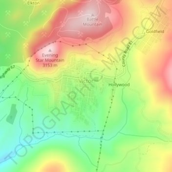
Name: Topografische Karte Victor, Höhe, Relief.
Ort: Victor, Teller County, Colorado, United States (38.70404 -105.14716 38.71428 -105.13556)
Durchschnittliche Höhe: 2’974 m
Minimale Höhe: 2’803 m
Maximale Höhe: 3’160 m
In 2022, youtubers The Baseball Bat Bros attempted to break the Guinness World Record for Longest home run hit, set by Babe Ruth in 1921 with a verified measurement of 575 feet. The attempt was made at The Gold Bowl baseball and soccer field. Victor, having one of the highest elevations in the United States was an ideal location as thinner air at high elevations creates less drag on a traveling baseball than at lower elevations, thus allowing it to travel farther in the air. Various high school, college, and former professional baseball players were invited to attempt to break the record but none were successful with elevated land beyond the outfield and unfavorable winds likely spoiling the attempts. The longest home run hit on the day was an estimated 534 feet.
Andere topografische Karten
Klicken Sie auf eine Karte, um ihre Topografie, ihre Höhe und ihr Relief anzuzeigen.
Woodland Park
United States > Colorado > Teller County
Woodland Park, Teller County, Colorado, 80863, United States
Durchschnittliche Höhe: 2’652 m
Midland
United States > Colorado > Teller County
Midland, Teller County, Colorado, United States
Durchschnittliche Höhe: 2’874 m
Cripple Creek
United States > Colorado > Teller County
Cripple Creek, Teller County, Colorado, United States
Durchschnittliche Höhe: 2’946 m
Florissant
United States > Colorado > Teller County
Florissant, Teller County, Colorado, United States
Durchschnittliche Höhe: 2’556 m
Divide
United States > Colorado > Teller County
Divide, Teller County, Colorado, United States
Durchschnittliche Höhe: 2’796 m
Woodland Park
United States > Colorado > Teller County > Woodland Park
Woodland Park, Teller County, Colorado, 80863, United States
Durchschnittliche Höhe: 2’657 m
Copper Mountain
United States > Colorado > Teller County
Copper Mountain, Teller County, Colorado, 80813, United States
Durchschnittliche Höhe: 2’946 m
Squaw Mountain
United States > Colorado > Teller County
Squaw Mountain, Teller County, Colorado, 80860, United States
Durchschnittliche Höhe: 2’977 m