
Topografische Karte Niksar
Interaktive Karte
Klicken Sie auf die Karte, um die Höhe anzuzeigen.
Niksar
Niksar is approximately 9,555 km2 (3,689 sq mi). It is located at 40°35' north latitude and 36°58' east longitude. Its average altitude is 350m above sea level. It is surrounded by Erbaa on the northwest, Tokat on the southwest, Almus on the south, Başçiftlik on the southeast and Akkuş on the north. It is one of the five largest counties of Tokat. The Canik Mountains are to the north, Dönek Mountain to the south, and the Niksar Lowland is situated between these mountains. The Niksar Lowland is one of the most important lowlands of the Black Sea Region. The Canik Mountains are covered with plateaus that lie parallel to the Black Sea. Çamiçi High Plateau is one of the most important ones.
Über diese Karte
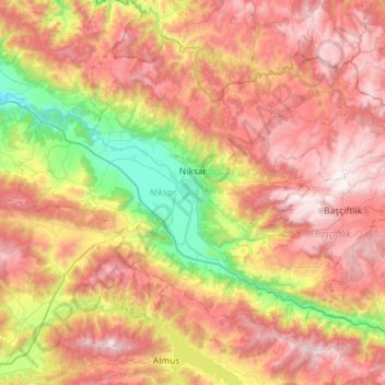
Name: Topografische Karte Niksar, Höhe, Relief.
Ort: Niksar, Tokat, Black Sea Region, 60600, Turkey (40.38944 36.67206 40.74426 37.24789)
Durchschnittliche Höhe: 1’009 m
Minimale Höhe: 213 m
Maximale Höhe: 1’823 m
Andere topografische Karten
Klicken Sie auf eine Karte, um ihre Topografie, ihre Höhe und ihr Relief anzuzeigen.
Turhal
Turhal is a town and a district of Tokat Province in the Black Sea region of Turkey. It is 48 km in the west of Tokat Province. Turhal is situated on a fertile plain fragmented by the Yeşil Irmak river. It has an elevation of approximately 530 m. The city is best known for its sugar beet processing plant…
Durchschnittliche Höhe: 599 m