
Spenden
Rüste dich für dein nächstes Abenteuer:
Als Amazon-Partner verdient diese Seite an qualifizierten Käufen, ohne dass Ihnen zusätzliche Kosten entstehen.
Topografische Karte Derby
Klicken Sie auf die Karte, um die Höhe anzuzeigen.
Spenden
Rüste dich für dein nächstes Abenteuer:
Als Amazon-Partner verdient diese Seite an qualifizierten Käufen, ohne dass Ihnen zusätzliche Kosten entstehen.
Über diese Karte
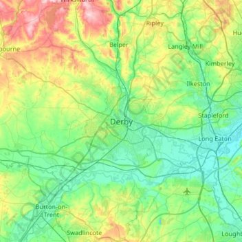
Name: Topografische Karte Derby, Höhe, Relief.
Durchschnittliche Höhe: 96 m
Minimale Höhe: 25 m
Maximale Höhe: 315 m
Spenden
Rüste dich für dein nächstes Abenteuer:
Als Amazon-Partner verdient diese Seite an qualifizierten Käufen, ohne dass Ihnen zusätzliche Kosten entstehen.
Andere topografische Karten
Klicken Sie auf eine Karte, um ihre Topografie, ihre Höhe und ihr Relief anzuzeigen.
Buxton
United Kingdom > England > Derbyshire > High Peak
Buxton has an oceanic climate with short, mild summers and long, cool winters. At about 1,000 feet (300 m) above sea level, As the highest market town in England, Buxton's elevation makes it cooler and wetter than surrounding towns, with a daytime temperature typically about 2 °C lower than Manchester.
Durchschnittliche Höhe: 334 m
Spenden
Rüste dich für dein nächstes Abenteuer:
Als Amazon-Partner verdient diese Seite an qualifizierten Käufen, ohne dass Ihnen zusätzliche Kosten entstehen.
Spenden
Rüste dich für dein nächstes Abenteuer:
Als Amazon-Partner verdient diese Seite an qualifizierten Käufen, ohne dass Ihnen zusätzliche Kosten entstehen.
Stanton by Bridge CP
United Kingdom > England > Derbyshire > South Derbyshire
Durchschnittliche Höhe: 67 m
Spenden
Rüste dich für dein nächstes Abenteuer:
Als Amazon-Partner verdient diese Seite an qualifizierten Käufen, ohne dass Ihnen zusätzliche Kosten entstehen.
Crich Chase
United Kingdom > England > Derbyshire > Amber Valley > Crich CP
Durchschnittliche Höhe: 148 m
Black Rocks
United Kingdom > England > Derbyshire > Derbyshire Dales > Cromford CP
Durchschnittliche Höhe: 199 m
Spenden
Rüste dich für dein nächstes Abenteuer:
Als Amazon-Partner verdient diese Seite an qualifizierten Käufen, ohne dass Ihnen zusätzliche Kosten entstehen.
Spenden
Rüste dich für dein nächstes Abenteuer:
Als Amazon-Partner verdient diese Seite an qualifizierten Käufen, ohne dass Ihnen zusätzliche Kosten entstehen.
Wingerworth
United Kingdom > England > Derbyshire > North East Derbyshire
Durchschnittliche Höhe: 149 m
Derwent
United Kingdom > England > Derbyshire > High Peak > Bamford > Yorkshire Bridge
Durchschnittliche Höhe: 291 m
Clay Cross CP
United Kingdom > England > Derbyshire > North East Derbyshire
Durchschnittliche Höhe: 133 m
Spenden
Rüste dich für dein nächstes Abenteuer:
Als Amazon-Partner verdient diese Seite an qualifizierten Käufen, ohne dass Ihnen zusätzliche Kosten entstehen.
Stretton CP
United Kingdom > England > Derbyshire > North East Derbyshire
Durchschnittliche Höhe: 133 m
Tansley CP
United Kingdom > England > Derbyshire > Derbyshire Dales > Matlock
Durchschnittliche Höhe: 219 m
Alfreton Park
United Kingdom > England > Derbyshire > Amber Valley > Alfreton CP > Oakerthorpe
Durchschnittliche Höhe: 116 m
Spenden
Rüste dich für dein nächstes Abenteuer:
Als Amazon-Partner verdient diese Seite an qualifizierten Käufen, ohne dass Ihnen zusätzliche Kosten entstehen.
Carsington Water
United Kingdom > England > Derbyshire > Derbyshire Dales
Durchschnittliche Höhe: 216 m
Horsley Woodhouse CP
United Kingdom > England > Derbyshire > Amber Valley
Durchschnittliche Höhe: 109 m
Grassmoor Country Park
United Kingdom > England > Derbyshire > North East Derbyshire > Corbriggs
Durchschnittliche Höhe: 116 m
Spenden
Rüste dich für dein nächstes Abenteuer:
Als Amazon-Partner verdient diese Seite an qualifizierten Käufen, ohne dass Ihnen zusätzliche Kosten entstehen.
Hungry Bentley CP
United Kingdom > England > Derbyshire > Derbyshire Dales
Durchschnittliche Höhe: 131 m
Mercia Marina
United Kingdom > England > Derbyshire > South Derbyshire > Willington CP
Durchschnittliche Höhe: 51 m
Spenden
Rüste dich für dein nächstes Abenteuer:
Als Amazon-Partner verdient diese Seite an qualifizierten Käufen, ohne dass Ihnen zusätzliche Kosten entstehen.
Peak Forest
United Kingdom > England > Derbyshire > High Peak > Peak Forest
Durchschnittliche Höhe: 374 m
Spenden
Rüste dich für dein nächstes Abenteuer:
Als Amazon-Partner verdient diese Seite an qualifizierten Käufen, ohne dass Ihnen zusätzliche Kosten entstehen.
Spenden
Rüste dich für dein nächstes Abenteuer:
Als Amazon-Partner verdient diese Seite an qualifizierten Käufen, ohne dass Ihnen zusätzliche Kosten entstehen.
Staunton Harold Reservoir
United Kingdom > England > Derbyshire > South Derbyshire > Melbourne CP
Durchschnittliche Höhe: 93 m
Ashover CP
United Kingdom > England > Derbyshire > North East Derbyshire
By the 18th century, there were several thousand acres of unenclosed moorland in the parish of Ashover, principally covered with heath. The only paths across this wilderness for roads were tracks in the sand or heath with here and there a stone post on the hills or elevations to serve as guides to the…
Durchschnittliche Höhe: 210 m
Spenden
Rüste dich für dein nächstes Abenteuer:
Als Amazon-Partner verdient diese Seite an qualifizierten Käufen, ohne dass Ihnen zusätzliche Kosten entstehen.
Rother Valley Country Park
United Kingdom > England > Derbyshire > Rotherham > Swallownest
Durchschnittliche Höhe: 62 m
Stanage Plantation
United Kingdom > England > Derbyshire > Derbyshire Dales > Hathersage
Durchschnittliche Höhe: 360 m
Whaley Bridge
United Kingdom > England > Derbyshire > High Peak > Buxworth
Durchschnittliche Höhe: 262 m
Spenden
Rüste dich für dein nächstes Abenteuer:
Als Amazon-Partner verdient diese Seite an qualifizierten Käufen, ohne dass Ihnen zusätzliche Kosten entstehen.
New Mills
United Kingdom > England > Derbyshire > High Peak
High Peak Borough Council have produced a Conservation Area Character Appraisal document, outlining the reasons that the Conservation Area has been designated as such. In justifying the reasons for designation, this document states of the town: "New Mills is a town of dramatic topography and origins that date…
Durchschnittliche Höhe: 229 m
Hungry Bentley CP
United Kingdom > England > Derbyshire > Derbyshire Dales
Durchschnittliche Höhe: 131 m
Bakewell CP
United Kingdom > England > Derbyshire > Derbyshire Dales
The Manchester, Buxton, Matlock and Midlands Junction Railway opened Bakewell railway station in 1862, then became part of the Midland Railway and later of the LMS main line from London to Manchester. John Ruskin objected to what he saw as desecration of the Derbyshire countryside and to the fact that "every…
Durchschnittliche Höhe: 194 m
Spenden
Rüste dich für dein nächstes Abenteuer:
Als Amazon-Partner verdient diese Seite an qualifizierten Käufen, ohne dass Ihnen zusätzliche Kosten entstehen.
Spenden
Rüste dich für dein nächstes Abenteuer:
Als Amazon-Partner verdient diese Seite an qualifizierten Käufen, ohne dass Ihnen zusätzliche Kosten entstehen.
Barrow upon Trent
United Kingdom > England > Derbyshire > South Derbyshire
Durchschnittliche Höhe: 43 m
Spenden
Rüste dich für dein nächstes Abenteuer:
Als Amazon-Partner verdient diese Seite an qualifizierten Käufen, ohne dass Ihnen zusätzliche Kosten entstehen.
Spenden
Rüste dich für dein nächstes Abenteuer:
Als Amazon-Partner verdient diese Seite an qualifizierten Käufen, ohne dass Ihnen zusätzliche Kosten entstehen.
Matlock Bath CP
United Kingdom > England > Derbyshire > Derbyshire Dales
Durchschnittliche Höhe: 187 m
Crowden Great Brook
United Kingdom > England > Derbyshire > High Peak > Tintwistle
Durchschnittliche Höhe: 459 m
Norwood Cottage Lakes
United Kingdom > England > Derbyshire > North East Derbyshire > Killamarsh
Durchschnittliche Höhe: 93 m
Spenden
Rüste dich für dein nächstes Abenteuer:
Als Amazon-Partner verdient diese Seite an qualifizierten Käufen, ohne dass Ihnen zusätzliche Kosten entstehen.
Spenden
Rüste dich für dein nächstes Abenteuer:
Als Amazon-Partner verdient diese Seite an qualifizierten Käufen, ohne dass Ihnen zusätzliche Kosten entstehen.
Padley Gorge
United Kingdom > England > Derbyshire > Derbyshire Dales > Grindleford
Durchschnittliche Höhe: 316 m
Spenden
Rüste dich für dein nächstes Abenteuer:
Als Amazon-Partner verdient diese Seite an qualifizierten Käufen, ohne dass Ihnen zusätzliche Kosten entstehen.
Bonsall CP
United Kingdom > England > Derbyshire > Derbyshire Dales > Matlock
Durchschnittliche Höhe: 225 m
Haddon Hall
United Kingdom > England > Derbyshire > Derbyshire Dales > Alport
Durchschnittliche Höhe: 158 m
Spenden
Rüste dich für dein nächstes Abenteuer:
Als Amazon-Partner verdient diese Seite an qualifizierten Käufen, ohne dass Ihnen zusätzliche Kosten entstehen.
Bakewell CP
United Kingdom > England > Derbyshire > Derbyshire Dales
The Manchester, Buxton, Matlock and Midlands Junction Railway opened Bakewell railway station in 1862, then became part of the Midland Railway and later of the LMS main line from London to Manchester. John Ruskin objected to what he saw as desecration of the Derbyshire countryside and to the fact that "every…
Durchschnittliche Höhe: 194 m
Spenden
Rüste dich für dein nächstes Abenteuer:
Als Amazon-Partner verdient diese Seite an qualifizierten Käufen, ohne dass Ihnen zusätzliche Kosten entstehen.
Spenden
Rüste dich für dein nächstes Abenteuer:
Als Amazon-Partner verdient diese Seite an qualifizierten Käufen, ohne dass Ihnen zusätzliche Kosten entstehen.
Blackwell in the Peak CP
United Kingdom > England > Derbyshire > Derbyshire Dales
Durchschnittliche Höhe: 331 m
Tideswell CP
United Kingdom > England > Derbyshire > Derbyshire Dales
Tideswell is a village, civil parish, and ward in the Peak District of Derbyshire, England. It lies 6 miles (9.7 km) east of Buxton on the B6049, in a wide valley on a limestone plateau, at an altitude of 1,000 feet (300 m) above sea level, and is within the District of Derbyshire Dales. The population…
Durchschnittliche Höhe: 321 m
Spenden
Rüste dich für dein nächstes Abenteuer:
Als Amazon-Partner verdient diese Seite an qualifizierten Käufen, ohne dass Ihnen zusätzliche Kosten entstehen.
Derwent
United Kingdom > England > Derbyshire > High Peak > Bamford > Yorkshire Bridge
Durchschnittliche Höhe: 293 m
Spenden
Rüste dich für dein nächstes Abenteuer:
Als Amazon-Partner verdient diese Seite an qualifizierten Käufen, ohne dass Ihnen zusätzliche Kosten entstehen.