
Topografische Karte Paonia
Interaktive Karte
Klicken Sie auf die Karte, um die Höhe anzuzeigen.
Über diese Karte
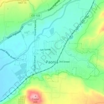
Name: Topografische Karte Paonia, Höhe, Relief.
Ort: Paonia, Delta County, Colorado, United States (38.86312 -107.60451 38.87868 -107.57663)
Durchschnittliche Höhe: 1’760 m
Minimale Höhe: 1’712 m
Maximale Höhe: 1’875 m
Andere topografische Karten
Klicken Sie auf eine Karte, um ihre Topografie, ihre Höhe und ihr Relief anzuzeigen.
Austin
United States > Colorado > Delta County
Austin, Delta County, Colorado, 81410, United States
Durchschnittliche Höhe: 1’576 m
Rim Rock Lake
United States > Colorado > Delta County
Rim Rock Lake, Delta County, Colorado, United States
Durchschnittliche Höhe: 3’113 m
Delta
United States > Colorado > Delta County
Delta, Delta County, Colorado, 81416, United States
Durchschnittliche Höhe: 1’550 m
Cedaredge
United States > Colorado > Delta County
Cedaredge, Delta County, Colorado, United States
Durchschnittliche Höhe: 1’883 m
Crawford
United States > Colorado > Delta County
Crawford, Delta County, Colorado, United States
Durchschnittliche Höhe: 2’020 m
Hotchkiss
United States > Colorado > Delta County
Hotchkiss, Delta County, Colorado, United States
Durchschnittliche Höhe: 1’655 m