
Topografische Karte Cedaredge
Interaktive Karte
Klicken Sie auf die Karte, um die Höhe anzuzeigen.
Über diese Karte
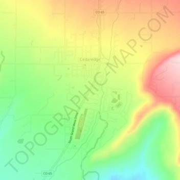
Name: Topografische Karte Cedaredge, Höhe, Relief.
Ort: Cedaredge, Delta County, Colorado, United States (38.87564 -107.93799 38.91431 -107.91177)
Durchschnittliche Höhe: 1’883 m
Minimale Höhe: 1’745 m
Maximale Höhe: 2’042 m
Located in a protected valley at 6,100 feet (1,900 m) in elevation, the Cedaredge Golf Club course has natural cedars and winding creek beds.
Andere topografische Karten
Klicken Sie auf eine Karte, um ihre Topografie, ihre Höhe und ihr Relief anzuzeigen.
Austin
United States > Colorado > Delta County
Austin, Delta County, Colorado, 81410, United States
Durchschnittliche Höhe: 1’576 m
Rim Rock Lake
United States > Colorado > Delta County
Rim Rock Lake, Delta County, Colorado, United States
Durchschnittliche Höhe: 3’113 m
Delta
United States > Colorado > Delta County
Delta, Delta County, Colorado, 81416, United States
Durchschnittliche Höhe: 1’550 m
Crawford
United States > Colorado > Delta County
Crawford, Delta County, Colorado, United States
Durchschnittliche Höhe: 2’020 m
Hotchkiss
United States > Colorado > Delta County
Hotchkiss, Delta County, Colorado, United States
Durchschnittliche Höhe: 1’655 m
Paonia
United States > Colorado > Delta County
Paonia, Delta County, Colorado, United States
Durchschnittliche Höhe: 1’760 m