
Topografische Karte San Frutos
Interaktive Karte
Klicken Sie auf die Karte, um die Höhe anzuzeigen.
Über diese Karte
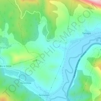
Name: Topografische Karte San Frutos, Höhe, Relief.
Ort: San Frutos, Oña, Burgos, Castilla y León, 09530, España (42.72352 -3.45859 42.74352 -3.43859)
Durchschnittliche Höhe: 654 m
Minimale Höhe: 578 m
Maximale Höhe: 886 m
Andere topografische Karten
Klicken Sie auf eine Karte, um ihre Topografie, ihre Höhe und ihr Relief anzuzeigen.
Cornudilla
España > Castilla y León > Oña
Cornudilla, Oña, Burgos, Castilla y León, 09210, España
Durchschnittliche Höhe: 647 m
Ventanas
España > Castilla y León > Oña
Ventanas, Oña, Burgos, Castilla y León, España
Durchschnittliche Höhe: 940 m
Mazo
España > Castilla y León > Oña
Mazo, Oña, Burgos, Castilla y León, España
Durchschnittliche Höhe: 839 m
Valdefrades
España > Castilla y León > Oña
Valdefrades, Oña, Burgos, Castilla y León, 09530, España
Durchschnittliche Höhe: 684 m
El Mazo
España > Castilla y León > Oña
El Mazo, Oña, Burgos, Castilla y León, España
Durchschnittliche Höhe: 839 m