
Topografische Karte Chubbuck
Interaktive Karte
Klicken Sie auf die Karte, um die Höhe anzuzeigen.
Über diese Karte
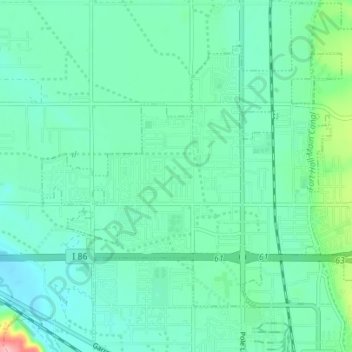
Name: Topografische Karte Chubbuck, Höhe, Relief.
Ort: Chubbuck, Bannock County, Idaho, 83202, United States (42.90573 -112.50598 42.94954 -112.41312)
Durchschnittliche Höhe: 1’377 m
Minimale Höhe: 1’339 m
Maximale Höhe: 1’544 m
Chubbuck is located at 42°55′18″N 112°28′3″W / 42.92167°N 112.46750°W / 42.92167; -112.46750 (42.921648, -112.467416), at an elevation of 4,472 feet (1,363 m) above sea level.
Andere topografische Karten
Klicken Sie auf eine Karte, um ihre Topografie, ihre Höhe und ihr Relief anzuzeigen.
Pocatello
United States > Idaho > Bannock County
Pocatello, Bannock County, Idaho, United States
Durchschnittliche Höhe: 1’580 m
Downey
United States > Idaho > Bannock County
Downey, Bannock County, Idaho, United States
Durchschnittliche Höhe: 1’482 m
Fort Hall
United States > Idaho > Bannock County
Fort Hall, Bannock County, Idaho, United States
Durchschnittliche Höhe: 1’377 m
Lava Hot Springs
United States > Idaho > Bannock County
Lava Hot Springs, Bannock County, Idaho, 83246, United States
Durchschnittliche Höhe: 1’611 m
McCammon
United States > Idaho > Bannock County
McCammon, Bannock County, Idaho, United States
Durchschnittliche Höhe: 1’465 m
Inkom
United States > Idaho > Bannock County
Inkom, Bannock County, Idaho, United States
Durchschnittliche Höhe: 1’447 m