
Topografische Karte Inkom
Interaktive Karte
Klicken Sie auf die Karte, um die Höhe anzuzeigen.
Über diese Karte
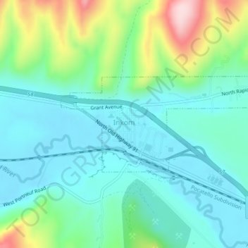
Name: Topografische Karte Inkom, Höhe, Relief.
Ort: Inkom, Bannock County, Idaho, United States (42.79061 -112.26408 42.80160 -112.22540)
Durchschnittliche Höhe: 1’447 m
Minimale Höhe: 1’374 m
Maximale Höhe: 1’666 m
Andere topografische Karten
Klicken Sie auf eine Karte, um ihre Topografie, ihre Höhe und ihr Relief anzuzeigen.
Pocatello
United States > Idaho > Bannock County
Pocatello, Bannock County, Idaho, United States
Durchschnittliche Höhe: 1’580 m
Downey
United States > Idaho > Bannock County
Downey, Bannock County, Idaho, United States
Durchschnittliche Höhe: 1’482 m
Fort Hall
United States > Idaho > Bannock County
Fort Hall, Bannock County, Idaho, United States
Durchschnittliche Höhe: 1’377 m
Lava Hot Springs
United States > Idaho > Bannock County
Lava Hot Springs, Bannock County, Idaho, 83246, United States
Durchschnittliche Höhe: 1’611 m
Chubbuck
United States > Idaho > Bannock County
Chubbuck, Bannock County, Idaho, 83202, United States
Durchschnittliche Höhe: 1’377 m
McCammon
United States > Idaho > Bannock County
McCammon, Bannock County, Idaho, United States
Durchschnittliche Höhe: 1’465 m