
Topografische Karte Pioneer Weapons Wildlife Management Area
Interaktive Karte
Klicken Sie auf die Karte, um die Höhe anzuzeigen.
Über diese Karte
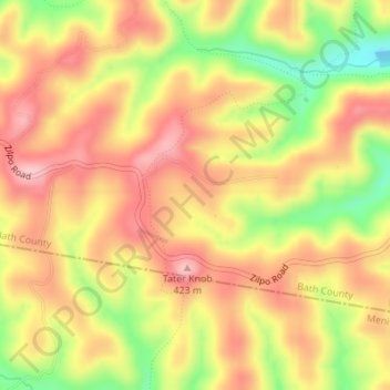
Name: Topografische Karte Pioneer Weapons Wildlife Management Area, Höhe, Relief.
Durchschnittliche Höhe: 323 m
Minimale Höhe: 223 m
Maximale Höhe: 390 m
Andere topografische Karten
Klicken Sie auf eine Karte, um ihre Topografie, ihre Höhe und ihr Relief anzuzeigen.
Sharpsburg
United States > Kentucky > Bath County
Sharpsburg, Bath County, Kentucky, United States
Durchschnittliche Höhe: 297 m
Olympia
United States > Kentucky > Bath County
Olympia, Bath County, Kentucky, 40358, United States
Durchschnittliche Höhe: 248 m
Owingsville
United States > Kentucky > Bath County
Owingsville, Bath County, Kentucky, 40360, United States
Durchschnittliche Höhe: 262 m
Salt Lick
United States > Kentucky > Bath County
Salt Lick, Bath County, Kentucky, United States
Durchschnittliche Höhe: 217 m