
Topografische Karte Salt Lick
Interaktive Karte
Klicken Sie auf die Karte, um die Höhe anzuzeigen.
Über diese Karte
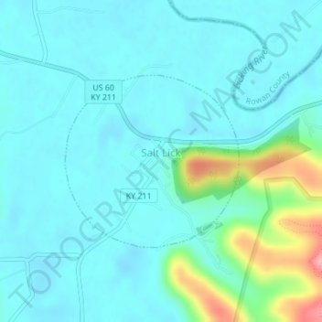
Name: Topografische Karte Salt Lick, Höhe, Relief.
Ort: Salt Lick, Bath County, Kentucky, United States (38.11210 -83.62489 38.12657 -83.60631)
Durchschnittliche Höhe: 217 m
Minimale Höhe: 195 m
Maximale Höhe: 316 m
Andere topografische Karten
Klicken Sie auf eine Karte, um ihre Topografie, ihre Höhe und ihr Relief anzuzeigen.
Sharpsburg
United States > Kentucky > Bath County
Sharpsburg, Bath County, Kentucky, United States
Durchschnittliche Höhe: 297 m
Olympia
United States > Kentucky > Bath County
Olympia, Bath County, Kentucky, 40358, United States
Durchschnittliche Höhe: 248 m
Owingsville
United States > Kentucky > Bath County
Owingsville, Bath County, Kentucky, 40360, United States
Durchschnittliche Höhe: 262 m
Pioneer Weapons Wildlife Management Area
United States > Kentucky > Bath County
Pioneer Weapons Wildlife Management Area, Bath County, Kentucky, United States
Durchschnittliche Höhe: 323 m