
Topografische Karte Indio
Interaktive Karte
Klicken Sie auf die Karte, um die Höhe anzuzeigen.
Über diese Karte
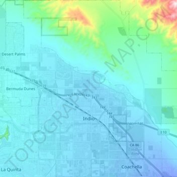
Name: Topografische Karte Indio, Höhe, Relief.
Ort: Indio, Riverside County, California, United States (33.67100 -116.30127 33.81671 -116.12929)
Durchschnittliche Höhe: 74 m
Minimale Höhe: -30 m
Maximale Höhe: 782 m
Indio is home of Riverside County's eastern administration offices. Palm Springs had more people from 1955 to 1992, when the US census announced that Indio surpassed Palm Springs and that title was returned to them. The official elevation of Indio is below sea level; the city hall is 14 feet (4 m) below sea level, as the eastern half of the Coachella Valley drops as low as 150 feet (50 m) below sea level (the lakeshore of the Salton Sea is 15 miles (24 km) south of Indio).
Andere topografische Karten
Klicken Sie auf eine Karte, um ihre Topografie, ihre Höhe und ihr Relief anzuzeigen.
Joshua Tree National Park
United States > California > Riverside County
Joshua Tree National Park, Riverside County, California, United States
Durchschnittliche Höhe: 639 m
Moreno Valley
United States > California > Riverside County
Moreno Valley, Riverside County, California, United States
Durchschnittliche Höhe: 527 m
Canyon Lake
United States > California > Riverside County > Canyon Lake
Canyon Lake, Riverside County, California, United States
Durchschnittliche Höhe: 461 m
Indian Wells
United States > California > Riverside County > Indian Wells
Indian Wells, Riverside County, California, 92210, United States
Durchschnittliche Höhe: 118 m
Corona
United States > California > Riverside County
Corona, Riverside County, CAL Fire Southern Region, California, United States
Durchschnittliche Höhe: 377 m
Lake Elsinore
United States > California > Riverside County > Lake Elsinore > Lake Elsinore
Lake Elsinore, Riverside County, California, 92532, United States
Durchschnittliche Höhe: 428 m
Coachella
United States > California > Riverside County > Coachella
Coachella, Riverside County, California, 92236, United States
Durchschnittliche Höhe: 22 m
Palm Springs
United States > California > Riverside County
Palm Springs, Riverside County, California, United States
Durchschnittliche Höhe: 698 m
Mesa Verde
United States > California > Riverside County > Mesa Verde
Mesa Verde, Riverside County, California, United States
Durchschnittliche Höhe: 120 m
Riverside
United States > California > Riverside County > Riverside
Riverside, Riverside County, California, United States
Durchschnittliche Höhe: 351 m