
Topografische Karte Joshua Tree National Park
Interaktive Karte
Klicken Sie auf die Karte, um die Höhe anzuzeigen.
Über diese Karte
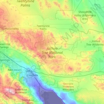
Name: Topografische Karte Joshua Tree National Park, Höhe, Relief.
Durchschnittliche Höhe: 639 m
Minimale Höhe: -71 m
Maximale Höhe: 2’612 m
Joshua Tree National Park is an American national park in southeastern California, east of San Bernardino and Los Angeles and north of Palm Springs. It is named after the Joshua trees (Yucca brevifolia) native to the Mojave Desert. Originally declared a national monument in 1936, Joshua Tree was redesignated as a national park in 1994 when the U.S. Congress passed the California Desert Protection Act. Encompassing a total of 795,156 acres (1,242.4 sq mi; 3,217.9 km2) – slightly larger than the state of Rhode Island – the park includes 429,690 acres (671.4 sq mi; 1,738.9 km2) of designated wilderness. Straddling San Bernardino and Riverside Counties, the park includes parts of two deserts, each an ecosystem whose characteristics are determined primarily by elevation: the higher Mojave Desert and the lower Colorado Desert. The Little San Bernardino Mountains traverse the southwest edge of the park.
Andere topografische Karten
Klicken Sie auf eine Karte, um ihre Topografie, ihre Höhe und ihr Relief anzuzeigen.
Moreno Valley
United States > California > Riverside County
Moreno Valley, Riverside County, California, United States
Durchschnittliche Höhe: 527 m
Indio
United States > California > Riverside County
Indio, Riverside County, California, United States
Durchschnittliche Höhe: 74 m
Canyon Lake
United States > California > Riverside County > Canyon Lake
Canyon Lake, Riverside County, California, United States
Durchschnittliche Höhe: 461 m
Indian Wells
United States > California > Riverside County > Indian Wells
Indian Wells, Riverside County, California, 92210, United States
Durchschnittliche Höhe: 118 m
Corona
United States > California > Riverside County
Corona, Riverside County, CAL Fire Southern Region, California, United States
Durchschnittliche Höhe: 377 m
Lake Elsinore
United States > California > Riverside County > Lake Elsinore > Lake Elsinore
Lake Elsinore, Riverside County, California, 92532, United States
Durchschnittliche Höhe: 428 m
Coachella
United States > California > Riverside County > Coachella
Coachella, Riverside County, California, 92236, United States
Durchschnittliche Höhe: 22 m
Palm Springs
United States > California > Riverside County
Palm Springs, Riverside County, California, United States
Durchschnittliche Höhe: 698 m
Mesa Verde
United States > California > Riverside County > Mesa Verde
Mesa Verde, Riverside County, California, United States
Durchschnittliche Höhe: 120 m
Riverside
United States > California > Riverside County > Riverside
Riverside, Riverside County, California, United States
Durchschnittliche Höhe: 351 m