
Spenden
Rüste dich für dein nächstes Abenteuer:
Als Amazon-Partner verdient diese Seite an qualifizierten Käufen, ohne dass Ihnen zusätzliche Kosten entstehen.
Topografische Karte Kengle
Klicken Sie auf die Karte, um die Höhe anzuzeigen.
Spenden
Rüste dich für dein nächstes Abenteuer:
Als Amazon-Partner verdient diese Seite an qualifizierten Käufen, ohne dass Ihnen zusätzliche Kosten entstehen.
Über diese Karte
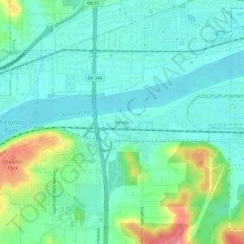
Name: Topografische Karte Kengle, Höhe, Relief.
Ort: Kengle, Tulsa, Oklahoma, 74127, United States (36.11648 -96.07139 36.15648 -96.03139)
Durchschnittliche Höhe: 209 m
Minimale Höhe: 184 m
Maximale Höhe: 283 m
Spenden
Rüste dich für dein nächstes Abenteuer:
Als Amazon-Partner verdient diese Seite an qualifizierten Käufen, ohne dass Ihnen zusätzliche Kosten entstehen.
Andere topografische Karten
Klicken Sie auf eine Karte, um ihre Topografie, ihre Höhe und ihr Relief anzuzeigen.
Tulsa
United States > Oklahoma > Tulsa
Tulsa, located in northeastern Oklahoma, is characterized by a diverse and rolling topography that marks its transition from the Great Plains to the Ozark foothills. The city's elevation averages around 700 feet (approximately 210 meters) above sea level, with some areas reaching heights of up to 1,050 feet…
Durchschnittliche Höhe: 221 m
Broken Arrow
United States > Oklahoma > Tulsa
Broken Arrow is located in the northeastern corner of Oklahoma. The city is part of the state's Green Country region known for its green vegetation, hills and lakes. Green Country is the most topographically diverse portion of the state with seven of Oklahoma's 11 eco-regions.
Durchschnittliche Höhe: 205 m
Bixby
United States > Oklahoma > Tulsa
Bixby is located at 35°57′39″N 95°52′42″W / 35.96083°N 95.87833°W / 35.96083; -95.87833 (35.960898, −95.878258). According to the United States Census Bureau, the city has a total area of 25.1 square miles (65.0 km2), of which 24.0 square miles (62.3 km2) is land and 1.0 square mile (2.7…
Durchschnittliche Höhe: 204 m
Spenden
Rüste dich für dein nächstes Abenteuer:
Als Amazon-Partner verdient diese Seite an qualifizierten Käufen, ohne dass Ihnen zusätzliche Kosten entstehen.
Tulsa
United States > Oklahoma > Tulsa
Tulsa is located in the northeastern corner of Oklahoma between the edge of the Great Plains and the foot of the Ozarks in a generally forested region of rolling hills. The city touches the eastern extent of the Cross Timbers, an ecoregion of forest and prairie transitioning from the drier plains of the west…
Durchschnittliche Höhe: 221 m
Broken Arrow
United States > Oklahoma > Tulsa
Broken Arrow is located in the northeastern corner of Oklahoma. The city is part of the state's Green Country region known for its green vegetation, hills and lakes. Green Country is the most topographically diverse portion of the state with seven of Oklahoma's 11 eco-regions.
Durchschnittliche Höhe: 205 m
Bixby
United States > Oklahoma > Tulsa
Bixby is located at 35°57′39″N 95°52′42″W / 35.96083°N 95.87833°W / 35.96083; -95.87833 (35.960898, −95.878258). According to the United States Census Bureau, the city has a total area of 25.1 square miles (65.0 km2), of which 24.0 square miles (62.3 km2) is land and 1.0 square mile (2.7…
Durchschnittliche Höhe: 204 m
Spenden
Rüste dich für dein nächstes Abenteuer:
Als Amazon-Partner verdient diese Seite an qualifizierten Käufen, ohne dass Ihnen zusätzliche Kosten entstehen.