Geolokalisieren

Topografische Karte Grand Coo

Interaktive Karte

Klicken Sie auf die Karte, um die Höhe anzuzeigen.

Über diese Karte

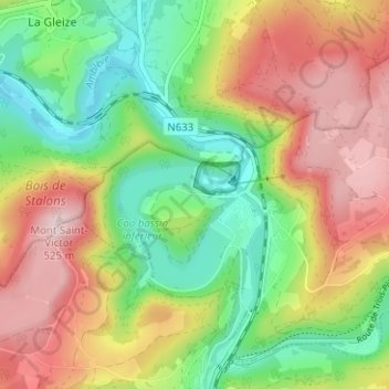
Name: Topografische Karte Grand Coo, Höhe, Relief.

Ort: Grand Coo, Stavelot, Verviers, Luik, Wallonië, 4970, België (50.37337 5.84957 50.41337 5.88957)

Durchschnittliche Höhe: 345 m

Minimale Höhe: 203 m

Maximale Höhe: 517 m

Andere topografische Karten

Klicken Sie auf eine Karte, um ihre Topografie, ihre Höhe und ihr Relief anzuzeigen.

Baronheid

België > Luik > Verviers > Stavelot > Hockai

Baronheid, Hockai, Stavelot, Verviers, Luik, Wallonië, 4970, België

Durchschnittliche Höhe: 518 m

Ster

België > Luik > Verviers > Stavelot > Francorchamps

Ster, Francorchamps, Stavelot, Verviers, Luik, Wallonië, 4970, België

Durchschnittliche Höhe: 499 m

Refat

België > Luik > Verviers > Stavelot > Francheville

Refat, Francheville, Stavelot, Verviers, Luik, Wallonië, 4970, België

Durchschnittliche Höhe: 424 m

La Vaulx Richard

België > Luik > Verviers > Stavelot

La Vaulx Richard, Stavelot, Verviers, Luik, Wallonië, 4970, België

Durchschnittliche Höhe: 397 m

Francorchamps

België > Luik > Verviers > Stavelot

Francorchamps, Stavelot, Verviers, Luik, Wallonië, 4970, België

Durchschnittliche Höhe: 482 m

Petit Coo

België > Luik > Verviers > Stavelot

Petit Coo, Stavelot, Verviers, Luik, Wallonië, 4970, België

Durchschnittliche Höhe: 349 m

Stavelot

België > Luik > Verviers > Stavelot

Stavelot, Verviers, Luik, Wallonië, 4970, België

Durchschnittliche Höhe: 401 m