
Topografische Karte Stavelot
Interaktive Karte
Klicken Sie auf die Karte, um die Höhe anzuzeigen.
Über diese Karte
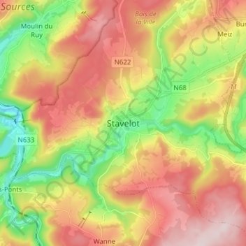
Name: Topografische Karte Stavelot, Höhe, Relief.
Ort: Stavelot, Verviers, Luik, Wallonië, 4970, België (50.35424 5.89103 50.43424 5.97103)
Durchschnittliche Höhe: 401 m
Minimale Höhe: 219 m
Maximale Höhe: 585 m
Stavelot (Duits: Stablo, Waals: Ståvleu) is een stad aan de Amblève in de provincie Luik, arrondissement Verviers in België. De stad telt zo'n 7169 inwoners en ligt op een hoogte van 350m boven de zeespiegel.
Andere topografische Karten
Klicken Sie auf eine Karte, um ihre Topografie, ihre Höhe und ihr Relief anzuzeigen.
La Vaulx Richard
België > Luik > Verviers > Stavelot
La Vaulx Richard, Stavelot, Verviers, Luik, Wallonië, 4970, België
Durchschnittliche Höhe: 397 m
Francorchamps
België > Luik > Verviers > Stavelot
Francorchamps, Stavelot, Verviers, Luik, Wallonië, 4970, België
Durchschnittliche Höhe: 482 m