
Topografische Karte Will County
Interaktive Karte
Klicken Sie auf die Karte, um die Höhe anzuzeigen.
Über diese Karte
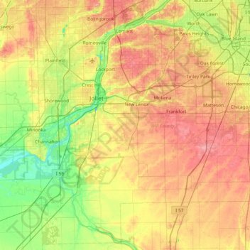
Name: Topografische Karte Will County, Höhe, Relief.
Ort: Will County, Illinois, United States (41.20159 -88.26195 41.72903 -87.52565)
Durchschnittliche Höhe: 199 m
Minimale Höhe: 149 m
Maximale Höhe: 263 m
Andere topografische Karten
Klicken Sie auf eine Karte, um ihre Topografie, ihre Höhe und ihr Relief anzuzeigen.
New Lenox
United States > Illinois > Will County
New Lenox, Will County, Illinois, 60451, United States
Durchschnittliche Höhe: 209 m
Lockport
United States > Illinois > Will County
Lockport, Will County, Illinois, United States
Durchschnittliche Höhe: 198 m
Elwood
United States > Illinois > Will County
Elwood, Will County, Illinois, United States
Durchschnittliche Höhe: 189 m
Braidwood
United States > Illinois > Will County
Braidwood, Will County, Illinois, 60408, United States
Durchschnittliche Höhe: 175 m