
Topografische Karte New Lenox
Interaktive Karte
Klicken Sie auf die Karte, um die Höhe anzuzeigen.
Über diese Karte
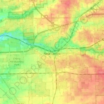
Name: Topografische Karte New Lenox, Höhe, Relief.
Ort: New Lenox, Will County, Illinois, 60451, United States (41.46079 -88.02610 41.56651 -87.90743)
Durchschnittliche Höhe: 209 m
Minimale Höhe: 177 m
Maximale Höhe: 237 m
New Lenox features the Sanctuary Golf Course. Bordering the west end of New Lenox and Joliet is Woodruff Golf Course. Opened in 1926, Woodruff is a course with sweeping elevation changes and small greens.
Andere topografische Karten
Klicken Sie auf eine Karte, um ihre Topografie, ihre Höhe und ihr Relief anzuzeigen.
Will County
United States > Illinois > Will County
Will County, Illinois, United States
Durchschnittliche Höhe: 199 m
Lockport
United States > Illinois > Will County
Lockport, Will County, Illinois, United States
Durchschnittliche Höhe: 198 m
Elwood
United States > Illinois > Will County
Elwood, Will County, Illinois, United States
Durchschnittliche Höhe: 189 m
Braidwood
United States > Illinois > Will County
Braidwood, Will County, Illinois, 60408, United States
Durchschnittliche Höhe: 175 m