
Spenden
Rüste dich für dein nächstes Abenteuer:
Als Amazon-Partner verdient diese Seite an qualifizierten Käufen, ohne dass Ihnen zusätzliche Kosten entstehen.
Topografische Karte Lolo Hot Springs
Klicken Sie auf die Karte, um die Höhe anzuzeigen.
Spenden
Rüste dich für dein nächstes Abenteuer:
Als Amazon-Partner verdient diese Seite an qualifizierten Käufen, ohne dass Ihnen zusätzliche Kosten entstehen.
Über diese Karte
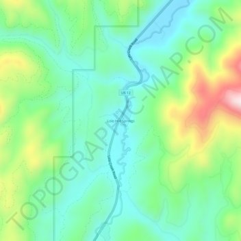
Name: Topografische Karte Lolo Hot Springs, Höhe, Relief.
Ort: Lolo Hot Springs, Missoula County, Montana, United States (46.70434 -114.55259 46.74434 -114.51259)
Durchschnittliche Höhe: 1’377 m
Minimale Höhe: 1’237 m
Maximale Höhe: 1’707 m
Spenden
Rüste dich für dein nächstes Abenteuer:
Als Amazon-Partner verdient diese Seite an qualifizierten Käufen, ohne dass Ihnen zusätzliche Kosten entstehen.
Andere topografische Karten
Klicken Sie auf eine Karte, um ihre Topografie, ihre Höhe und ihr Relief anzuzeigen.
Missoula
United States > Montana > Missoula County
Missoula is located at the western edge of Montana, approximately 45 miles (70 km) from the Idaho border. The city is at an elevation of 3,209 feet (978 m) above sea level, with nearby Mount Sentinel and Mount Jumbo steeply rising to 5,158 feet (1,572 m) and 4,768 feet (1,453 m), respectively. According to the…
Durchschnittliche Höhe: 1’173 m
Spenden
Rüste dich für dein nächstes Abenteuer:
Als Amazon-Partner verdient diese Seite an qualifizierten Käufen, ohne dass Ihnen zusätzliche Kosten entstehen.
Missoula
United States > Montana > Missoula County
Missoula is located at the western edge of Montana, less than 25 miles (40 km) from the Idaho border as the crow flies. By highway it is 117 miles (188 km) south of Kalispell, 118 miles (190 km) northwest of Butte and 165 miles (266 km) southeast of Coeur d'Alene, Idaho. The city is at an elevation of 3,209…
Durchschnittliche Höhe: 1’173 m
Missoula
United States > Montana > Missoula County
Missoula is located at the western edge of Montana, approximately 45 miles (70 km) from the Idaho border. The city is at an elevation of 3,209 feet (978 m) above sea level, with nearby Mount Sentinel and Mount Jumbo steeply rising to 5,158 feet (1,572 m) and 4,768 feet (1,453 m), respectively. According to the…
Durchschnittliche Höhe: 1’173 m
Spenden
Rüste dich für dein nächstes Abenteuer:
Als Amazon-Partner verdient diese Seite an qualifizierten Käufen, ohne dass Ihnen zusätzliche Kosten entstehen.
Missoula
United States > Montana > Missoula County
Missoula is located at the western edge of Montana, less than 25 miles (40 km) from the Idaho border as the crow flies. By highway it is 117 miles (188 km) south of Kalispell, 118 miles (190 km) northwest of Butte and 165 miles (266 km) southeast of Coeur d'Alene, Idaho. The city is at an elevation of 3,209…
Durchschnittliche Höhe: 1’173 m
Spenden
Rüste dich für dein nächstes Abenteuer:
Als Amazon-Partner verdient diese Seite an qualifizierten Käufen, ohne dass Ihnen zusätzliche Kosten entstehen.
Spenden
Rüste dich für dein nächstes Abenteuer:
Als Amazon-Partner verdient diese Seite an qualifizierten Käufen, ohne dass Ihnen zusätzliche Kosten entstehen.