
Spenden
Rüste dich für dein nächstes Abenteuer:
Als Amazon-Partner verdient diese Seite an qualifizierten Käufen, ohne dass Ihnen zusätzliche Kosten entstehen.
Topografische Karte Mount LeConte
Klicken Sie auf die Karte, um die Höhe anzuzeigen.
Spenden
Rüste dich für dein nächstes Abenteuer:
Als Amazon-Partner verdient diese Seite an qualifizierten Käufen, ohne dass Ihnen zusätzliche Kosten entstehen.
Über diese Karte
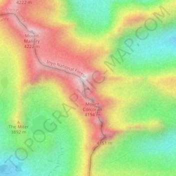
Name: Topografische Karte Mount LeConte, Höhe, Relief.
Ort: Mount LeConte, Inyo County, California, United States (36.54157 -118.25227 36.54167 -118.25217)
Durchschnittliche Höhe: 3’797 m
Minimale Höhe: 3’421 m
Maximale Höhe: 4’219 m
Spenden
Rüste dich für dein nächstes Abenteuer:
Als Amazon-Partner verdient diese Seite an qualifizierten Käufen, ohne dass Ihnen zusätzliche Kosten entstehen.
Andere topografische Karten
Klicken Sie auf eine Karte, um ihre Topografie, ihre Höhe und ihr Relief anzuzeigen.
Lone Pine
United States > California > Inyo County
Lone Pine is a census-designated place (CDP) in Inyo County, California, United States. Lone Pine is located 16 mi (26 km) south-southeast of Independence, at an elevation of 3,727 ft (1,136 m). The population was 2,035 at the 2010 census, up from 1,655 at the 2000 census. The town is located in the Owens…
Durchschnittliche Höhe: 1’298 m
Bishop
United States > California > Inyo County
Bishop (formerly Bishop Creek) is a city in California, United States. It is the largest populated place and only incorporated city in Inyo County. Bishop is located near the northern end of the Owens Valley, at an elevation of 4,150 feet (1,260 m). The city was named after Bishop Creek, flowing out of the…
Durchschnittliche Höhe: 1’265 m
Furnace Creek
United States > California > Inyo County > Indian Village
Furnace Creek (formerly Greenland Ranch) is a census-designated place (CDP) in Inyo County, California, United States. The population was 136 at the 2020 census, up from 24 at the 2010 census. The elevation of the village is 190 feet (58 m) below sea level. The visitor center, museum, and headquarters of Death…
Durchschnittliche Höhe: 166 m
Spenden
Rüste dich für dein nächstes Abenteuer:
Als Amazon-Partner verdient diese Seite an qualifizierten Käufen, ohne dass Ihnen zusätzliche Kosten entstehen.
Big Pine
United States > California > Inyo County > Big Pine
Big Pine (formerly, Bigpine) is a census-designated place (CDP) in Inyo County, California, United States. Big Pine is located approximately 15 miles (24 km) south-southeast of Bishop, at an elevation of 3,989 feet (1,216 m). The population was 1,756 at the 2010 census, up from 1,350 at the 2000 census. The…
Durchschnittliche Höhe: 1’228 m
Spenden
Rüste dich für dein nächstes Abenteuer:
Als Amazon-Partner verdient diese Seite an qualifizierten Käufen, ohne dass Ihnen zusätzliche Kosten entstehen.
Palisade Glacier
United States > California > Inyo County
The Palisade Glacier is a glacier located on the northeast side of the Palisades within the John Muir Wilderness in the central Sierra Nevada of California. The glacier descends from the flanks of four fourteeners, or mountain peaks over 14,000 ft (4,300 m) in elevation, including North Palisade (14,242 ft…
Durchschnittliche Höhe: 3’839 m
Independence
United States > California > Inyo County > Independence
Independence is an unincorporated census-designated place in and the county seat of Inyo County, California. Independence is located 41 miles (66 km) south-southeast of Bishop, at an elevation of 3930 feet (1198 m). The population of this census-designated place was 593 at the 2020 census, down from 669 at the…
Durchschnittliche Höhe: 1’199 m
Badwater Basin
United States > California > Inyo County
The pool is not the lowest point of the basin: the lowest point (which is only slightly lower) is several miles to the west and varies in position, depending on rainfall and evaporation patterns. The salt flats are hazardous to traverse (in many cases being only a thin white crust over mud), and so the sign…
Durchschnittliche Höhe: 152 m
Spenden
Rüste dich für dein nächstes Abenteuer:
Als Amazon-Partner verdient diese Seite an qualifizierten Käufen, ohne dass Ihnen zusätzliche Kosten entstehen.
Ancient Bristlecone Pine Forest
United States > California > Inyo County
Durchschnittliche Höhe: 2’846 m
Spenden
Rüste dich für dein nächstes Abenteuer:
Als Amazon-Partner verdient diese Seite an qualifizierten Käufen, ohne dass Ihnen zusätzliche Kosten entstehen.
Manzanar National Historic Site
United States > California > Inyo County > Independence
The Manzanar facility was located between Lone Pine and Independence. The weather at Manzanar caused suffering for the inmates, few of whom were accustomed to the extremes of the area's climate. While the majority of people were from the Los Angeles area, some were from places with much different climates…
Durchschnittliche Höhe: 1’189 m
Spenden
Rüste dich für dein nächstes Abenteuer:
Als Amazon-Partner verdient diese Seite an qualifizierten Käufen, ohne dass Ihnen zusätzliche Kosten entstehen.
Badwater Basin
United States > California > Inyo County
The pool is not the lowest point of the basin: the lowest point (which is only slightly lower) is several miles to the west and varies in position, depending on rainfall and evaporation patterns. The salt flats are hazardous to traverse (in many cases being only a thin white crust over mud), and so the sign…
Durchschnittliche Höhe: 152 m
Spenden
Rüste dich für dein nächstes Abenteuer:
Als Amazon-Partner verdient diese Seite an qualifizierten Käufen, ohne dass Ihnen zusätzliche Kosten entstehen.
Badwater Basin
United States > California > Inyo County
The pool is not the lowest point of the basin: the lowest point (which is only slightly lower) is several miles to the west and varies in position, depending on rainfall and evaporation patterns. The salt flats are hazardous to traverse (in many cases being only a thin white crust over mud), and so the sign…
Durchschnittliche Höhe: 152 m
Bishop
United States > California > Inyo County
Bishop (formerly Bishop Creek) is a city in California, United States. It is the largest populated place and only incorporated city in Inyo County. Bishop is located near the northern end of the Owens Valley, at an elevation of 4,150 feet (1,260 m). The city was named after Bishop Creek, flowing out of the…
Durchschnittliche Höhe: 1’265 m
Tecopa
United States > California > Inyo County > Tecopa
Tecopa (formerly Brownsville[4]) is a census-designated place (CDP) in the Mojave Desert, in Inyo County, California, United States. Tecopa is located 9 miles (14 km) south-southeast of Shoshone,[4] at an elevation of 1,339 feet (408 m).[3] The population was 150 at the 2010 census, up from 99 at the 2000…
Durchschnittliche Höhe: 508 m
Spenden
Rüste dich für dein nächstes Abenteuer:
Als Amazon-Partner verdient diese Seite an qualifizierten Käufen, ohne dass Ihnen zusätzliche Kosten entstehen.