
Topografische Karte Prescott
Interaktive Karte
Klicken Sie auf die Karte, um die Höhe anzuzeigen.
Über diese Karte
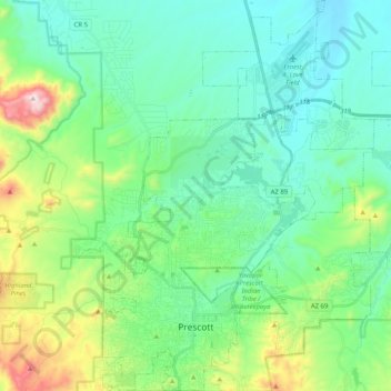
Name: Topografische Karte Prescott, Höhe, Relief.
Ort: Prescott, Yavapai County, Arizona, United States (34.51253 -112.52996 34.67994 -112.37610)
Durchschnittliche Höhe: 1’674 m
Minimale Höhe: 1’486 m
Maximale Höhe: 2’302 m
Prescott is in the Bradshaw Mountains of central Arizona, at an elevation of 5,400 feet (1,600 m). The city has a Mediterranean climate (Köppen Csa) bordering on a Humid subtropical climate (Köppen Cfa); however, unlike most other locations in this climate class, there is a pronounced summer wet season due to the North American Monsoon.
Andere topografische Karten
Klicken Sie auf eine Karte, um ihre Topografie, ihre Höhe und ihr Relief anzuzeigen.
Humbug
United States > Arizona > Yavapai County
Humbug, Yavapai County, Arizona, United States
Durchschnittliche Höhe: 875 m
Diamond Valley
United States > Arizona > Yavapai County > Diamond Valley
Diamond Valley, Yavapai County, Arizona, 86134, United States
Durchschnittliche Höhe: 1’658 m
Audley
United States > Arizona > Yavapai County
Audley, Yavapai County, Arizona, 96337, United States
Durchschnittliche Höhe: 1’589 m