
Topografische Karte Humbug
Interaktive Karte
Klicken Sie auf die Karte, um die Höhe anzuzeigen.
Über diese Karte
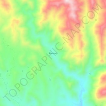
Name: Topografische Karte Humbug, Höhe, Relief.
Ort: Humbug, Yavapai County, Arizona, United States (34.03444 -112.34313 34.07444 -112.30313)
Durchschnittliche Höhe: 875 m
Minimale Höhe: 673 m
Maximale Höhe: 1’169 m
Andere topografische Karten
Klicken Sie auf eine Karte, um ihre Topografie, ihre Höhe und ihr Relief anzuzeigen.
Prescott
United States > Arizona > Yavapai County
Prescott, Yavapai County, Arizona, United States
Durchschnittliche Höhe: 1’674 m
Diamond Valley
United States > Arizona > Yavapai County > Diamond Valley
Diamond Valley, Yavapai County, Arizona, 86134, United States
Durchschnittliche Höhe: 1’658 m
Audley
United States > Arizona > Yavapai County
Audley, Yavapai County, Arizona, 96337, United States
Durchschnittliche Höhe: 1’589 m