
Topografische Karte Uhland
Interaktive Karte
Klicken Sie auf die Karte, um die Höhe anzuzeigen.
Über diese Karte
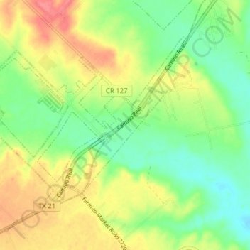
Name: Topografische Karte Uhland, Höhe, Relief.
Ort: Uhland, Caldwell County, Texas, United States (29.94099 -97.82884 29.97998 -97.76512)
Durchschnittliche Höhe: 180 m
Minimale Höhe: 151 m
Maximale Höhe: 217 m
Andere topografische Karten
Klicken Sie auf eine Karte, um ihre Topografie, ihre Höhe und ihr Relief anzuzeigen.
Dale
United States > Texas > Caldwell County
Dale, Caldwell County, Texas, 78616, United States
Durchschnittliche Höhe: 155 m
Lockhart
United States > Texas > Caldwell County
Lockhart, Caldwell County, Texas, 78644, United States
Durchschnittliche Höhe: 156 m
Fentress
United States > Texas > Caldwell County > Fentress
Fentress, Caldwell County, Texas, 78922, United States
Durchschnittliche Höhe: 139 m
Lockhart
United States > Texas > Caldwell County > Lockhart > Lockhart
Lockhart, Caldwell County, Texas, 78644, United States
Durchschnittliche Höhe: 157 m
Luling
United States > Texas > Caldwell County
Luling, Caldwell County, Texas, 78468, United States
Durchschnittliche Höhe: 121 m