
Topografische Karte Lac à Bélair
Interaktive Karte
Klicken Sie auf die Karte, um die Höhe anzuzeigen.
Über diese Karte
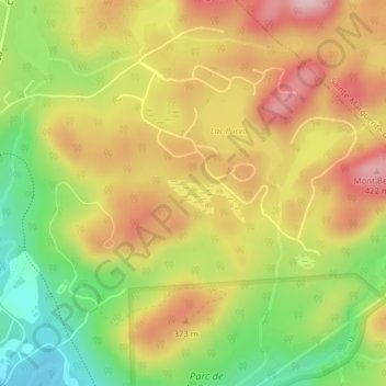
Name: Topografische Karte Lac à Bélair, Höhe, Relief.
Durchschnittliche Höhe: 314 m
Minimale Höhe: 194 m
Maximale Höhe: 421 m
Andere topografische Karten
Klicken Sie auf eine Karte, um ihre Topografie, ihre Höhe und ihr Relief anzuzeigen.
Mont Gabriel
Canada > Quebec > Les Pays-d'en-Haut > Sainte-Adèle
Mont Gabriel, Sainte-Adèle, Les Pays-d'en-Haut, Laurentides, Quebec, J8B 2J8, Canada
Durchschnittliche Höhe: 248 m
Lac Philippe
Canada > Quebec > Les Pays-d'en-Haut > Sainte-Adèle
Lac Philippe, Sainte-Adèle, Les Pays-d'en-Haut, Laurentides, Quebec, Canada
Durchschnittliche Höhe: 384 m
Glen Wexford
Canada > Quebec > Les Pays-d'en-Haut > Sainte-Adèle
Glen Wexford, Sainte-Adèle, Les Pays-d'en-Haut, Laurentides, Quebec, J8B 2N6, Canada
Durchschnittliche Höhe: 296 m