
Topografische Karte Salerno Lake
Interaktive Karte
Klicken Sie auf die Karte, um die Höhe anzuzeigen.
Über diese Karte
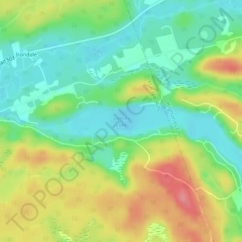
Name: Topografische Karte Salerno Lake, Höhe, Relief.
Durchschnittliche Höhe: 323 m
Minimale Höhe: 288 m
Maximale Höhe: 375 m
Andere topografische Karten
Klicken Sie auf eine Karte, um ihre Topografie, ihre Höhe und ihr Relief anzuzeigen.
Irondale
Canada > Ontario > Haliburton County > Minden Hills
Irondale, Minden Hills, Haliburton County, Central Ontario, Ontario, K0M 1X0, Canada
Durchschnittliche Höhe: 331 m
Minden
Canada > Ontario > Haliburton County > Minden Hills
Minden, Minden Hills, Haliburton County, Central Ontario, Ontario, K0M 2K0, Canada
Durchschnittliche Höhe: 320 m
Gull Lake
Canada > Ontario > Haliburton County > Minden Hills
Gull Lake, Minden Hills, Haliburton County, Central Ontario, Ontario, Canada
Durchschnittliche Höhe: 281 m
Howland Lake
Canada > Ontario > Haliburton County > Minden Hills
Howland Lake, Minden Hills, Haliburton County, Central Ontario, Ontario, Canada
Durchschnittliche Höhe: 317 m
Mountain Lake
Canada > Ontario > Haliburton County > Minden Hills
Mountain Lake, Minden Hills, Haliburton County, Central Ontario, Ontario, K0M 1J0, Canada
Durchschnittliche Höhe: 326 m
Bob Lake
Canada > Ontario > Haliburton County > Minden Hills
Bob Lake, Minden Hills, Haliburton County, Central Ontario, Ontario, Canada
Durchschnittliche Höhe: 319 m
Twelve Mile Lake
Canada > Ontario > Haliburton County > Minden Hills
Twelve Mile Lake, Minden Hills, Haliburton County, Central Ontario, Ontario, K0M 1J0, Canada
Durchschnittliche Höhe: 324 m
Minden Lake
Canada > Ontario > Haliburton County > Minden Hills > Minden
Minden Lake, Minden, Minden Hills, Haliburton County, Central Ontario, Ontario, Canada
Durchschnittliche Höhe: 321 m