
Topografische Karte Pinedale
Interaktive Karte
Klicken Sie auf die Karte, um die Höhe anzuzeigen.
Über diese Karte
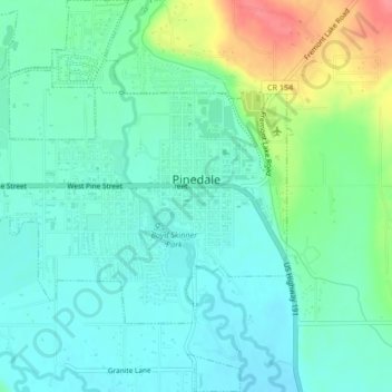
Name: Topografische Karte Pinedale, Höhe, Relief.
Ort: Pinedale, Sublette County, Wyoming, 82941, United States (42.85040 -109.89102 42.88123 -109.85054)
Durchschnittliche Höhe: 2’196 m
Minimale Höhe: 2’175 m
Maximale Höhe: 2’252 m
Pinedale is located at 42°51′58″N 109°51′53″W / 42.86611°N 109.86472°W / 42.86611; -109.86472 (42.866162, −109.864622) and sits at an elevation of 7,175 feet above sea level. According to the United States Census Bureau, the town has a total area of 2.15 square miles (5.57 km2), all land.
Andere topografische Karten
Klicken Sie auf eine Karte, um ihre Topografie, ihre Höhe und ihr Relief anzuzeigen.
Downs Mountain
United States > Wyoming > Sublette County
Downs Mountain, Sublette County, Wyoming, United States
Durchschnittliche Höhe: 3’777 m
Big Sandy Lake
United States > Wyoming > Sublette County
Big Sandy Lake, Sublette County, Wyoming, United States
Durchschnittliche Höhe: 3’103 m
Pine Creek
United States > Wyoming > Sublette County > Pinedale
Pine Creek, Pinedale, Sublette County, Wyoming, 82941, United States
Durchschnittliche Höhe: 2’188 m
Bridger Wilderness
United States > Wyoming > Sublette County
Bridger Wilderness, Sublette County, Wyoming, United States
Durchschnittliche Höhe: 2’677 m