
Topografische Karte Bridger Wilderness
Interaktive Karte
Klicken Sie auf die Karte, um die Höhe anzuzeigen.
Über diese Karte
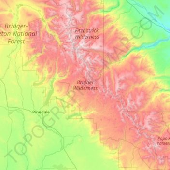
Name: Topografische Karte Bridger Wilderness, Höhe, Relief.
Durchschnittliche Höhe: 2’677 m
Minimale Höhe: 1’730 m
Maximale Höhe: 4’156 m
There are 600 miles (970 km) of hiking trails maintained in the wilderness, but with much of the terrain being steep and with many large mountain peaks to climb, many trails provide access climbing routes. Camping is permitted as long as a distance of at least 200 feet (61 m) minimum is maintained away from lakes and streams. Due to the high altitude associated with this wilderness, it is not uncommon to have freezing weather, especially at night anytime of the year. In the summer months mosquitos can also be a problem.
Andere topografische Karten
Klicken Sie auf eine Karte, um ihre Topografie, ihre Höhe und ihr Relief anzuzeigen.
Downs Mountain
United States > Wyoming > Sublette County
Downs Mountain, Sublette County, Wyoming, United States
Durchschnittliche Höhe: 3’777 m
Big Sandy Lake
United States > Wyoming > Sublette County
Big Sandy Lake, Sublette County, Wyoming, United States
Durchschnittliche Höhe: 3’103 m
Pine Creek
United States > Wyoming > Sublette County > Pinedale
Pine Creek, Pinedale, Sublette County, Wyoming, 82941, United States
Durchschnittliche Höhe: 2’188 m
Pinedale
United States > Wyoming > Sublette County
Pinedale, Sublette County, Wyoming, 82941, United States
Durchschnittliche Höhe: 2’196 m