
Spenden
Rüste dich für dein nächstes Abenteuer:
Als Amazon-Partner verdient diese Seite an qualifizierten Käufen, ohne dass Ihnen zusätzliche Kosten entstehen.
Topografische Karte Texola
Klicken Sie auf die Karte, um die Höhe anzuzeigen.
Spenden
Rüste dich für dein nächstes Abenteuer:
Als Amazon-Partner verdient diese Seite an qualifizierten Käufen, ohne dass Ihnen zusätzliche Kosten entstehen.
Über diese Karte
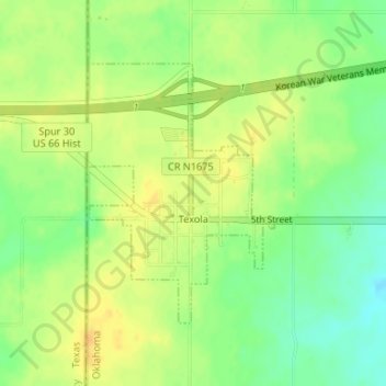
Name: Topografische Karte Texola, Höhe, Relief.
Ort: Texola, Beckham County, Oklahoma, 73668, United States (35.21194 -100.00035 35.23009 -99.98273)
Durchschnittliche Höhe: 654 m
Minimale Höhe: 637 m
Maximale Höhe: 667 m
Spenden
Rüste dich für dein nächstes Abenteuer:
Als Amazon-Partner verdient diese Seite an qualifizierten Käufen, ohne dass Ihnen zusätzliche Kosten entstehen.
Andere topografische Karten
Klicken Sie auf eine Karte, um ihre Topografie, ihre Höhe und ihr Relief anzuzeigen.
Sayre
United States > Oklahoma > Beckham County > Sayre > Sayre
Sayre is located at 35°17′56″N 99°38′12″W / 35.29889°N 99.63667°W / 35.29889; -99.63667 (35.298940, -99.636556). It is located on the North Fork of the Red River, at an elevation of 1,800 feet (550 m) and 128 miles (206 km) west of Oklahoma City. The area is dominated by low rolling red clay hills.
Durchschnittliche Höhe: 560 m