
Topografische Karte Lake County
Interaktive Karte
Klicken Sie auf die Karte, um die Höhe anzuzeigen.
Über diese Karte
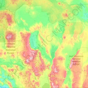
Name: Topografische Karte Lake County, Höhe, Relief.
Ort: Lake County, Oregon, United States of America (41.99301 -121.35122 43.61761 -119.35940)
Durchschnittliche Höhe: 1’540 m
Minimale Höhe: 1’233 m
Maximale Höhe: 2’530 m
Lake County ranges in elevation from 4,130 to 8,446 feet (1,259 to 2,574 m). The highest point in Lake County is Crane Mountain. The mountain is located 6 miles (9.7 km) north of the California border. Lake County has six other peaks with elevations above 8,000 feet (2,400 m), all located in the southern half of the county. Hager Mountain is the highest peak in the northern part of the county.
Andere topografische Karten
Klicken Sie auf eine Karte, um ihre Topografie, ihre Höhe und ihr Relief anzuzeigen.
Boring
United States of America > Oregon > Boring
Boring, Clackamas County, Oregon, 97009, United States of America
Durchschnittliche Höhe: 183 m
Rhododendron
United States of America > Oregon > Rhododendron
Rhododendron, The Villages at Mount Hood, Clackamas County, Oregon, 97049, United States of America
Durchschnittliche Höhe: 735 m
Iron Knob
United States of America > Oregon
Iron Knob, Jackson County, Oregon, United States of America
Durchschnittliche Höhe: 861 m
Morton Island
United States of America > Oregon
Morton Island, Malheur County, Oregon, United States of America
Durchschnittliche Höhe: 661 m
Wemme
United States of America > Oregon > Wemme
Wemme, The Villages at Mount Hood, Clackamas County, Oregon, 97067, United States of America
Durchschnittliche Höhe: 494 m
Barlow
United States of America > Oregon > Barlow
Barlow, Clackamas County, Oregon, United States of America
Durchschnittliche Höhe: 31 m
McKenzie River
United States of America > Oregon
McKenzie River, Lane County, Oregon, 97413, United States of America
Durchschnittliche Höhe: 431 m
Hillsboro
United States of America > Oregon > Hillsboro
Hillsboro, Washington County, Oregon, United States of America
Durchschnittliche Höhe: 53 m
Hail Creek
United States of America > Oregon
Hail Creek, Crook County, Oregon, United States of America
Durchschnittliche Höhe: 1’412 m