
Topografische Karte Potenza
Interaktive Karte
Klicken Sie auf die Karte, um die Höhe anzuzeigen.
Über diese Karte
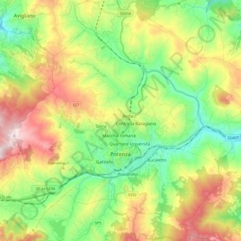
Name: Topografische Karte Potenza, Höhe, Relief.
Ort: Potenza, Basilicata, Italy (40.58025 15.70628 40.74174 15.90302)
Durchschnittliche Höhe: 872 m
Minimale Höhe: 574 m
Maximale Höhe: 1’347 m
The first settlement of Potentia (Potenza's original Latin name) was probably located at a lower elevation than at present, some 10 kilometres (6 miles) south of today's Potenza. The Lucani of Potentia sided against Rome's enemies during the latter's wars against the Samnites and the Bruttii. Subjugated during the 4th century BC (later gaining the status of municipium), the Potentini rebelled after the Roman defeat at Cannae in 216 BC. However, the Battle of the Metaurus marked the end of any Carthaginian aspirations in Italy and Potentia was reconquered by the Romans and reduced to the status of military colony.
Andere topografische Karten
Klicken Sie auf eine Karte, um ihre Topografie, ihre Höhe und ihr Relief anzuzeigen.
Castelsaraceno
Italy > Basilicata > Potenza
Castelsaraceno, Potenza, Basilicata, Italy
Durchschnittliche Höhe: 1’104 m
Viadotto Pantanelle
Italy > Basilicata > Potenza > Nemoli
Viadotto Pantanelle, Nemoli, Potenza, Basilicata, Italy
Durchschnittliche Höhe: 1’685 m
Melfi
Italy > Basilicata > Potenza
Melfi, Potenza, Basilicata, 85025, Italy
Durchschnittliche Höhe: 377 m
Senise
Italy > Basilicata > Potenza
Senise, Potenza, Basilicata, 85038, Italy
Durchschnittliche Höhe: 378 m
Barile
Italy > Basilicata > Potenza
Barile, Potenza, Basilicata, 85022, Italy
Durchschnittliche Höhe: 598 m
Porco Morto
Italy > Basilicata > Potenza > Picerno > Porco Morto
Porco Morto, Picerno, Potenza, Basilicata, Italy
Durchschnittliche Höhe: 1’071 m
Balvano
Italy > Basilicata > Potenza > Balvano
Balvano, Potenza, Basilicata, Italy
Durchschnittliche Höhe: 621 m
Bella
Italy > Basilicata > Potenza > Bella
Bella, Potenza, Basilicata, Italy
Durchschnittliche Höhe: 719 m