Geolokalisieren

Topografische Karte Fresno

Klicken Sie auf die Karte, um die Höhe anzuzeigen.

Über diese Karte

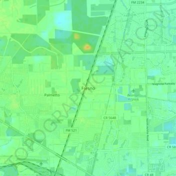
Name: Topografische Karte Fresno, Höhe, Relief.

Ort: Fresno, Fort Bend County, Texas, 77545, United States (29.49885 -95.48744 29.57885 -95.40744)

Durchschnittliche Höhe: 21 m

Minimale Höhe: 12 m

Maximale Höhe: 35 m

Andere topografische Karten

Klicken Sie auf eine Karte, um ihre Topografie, ihre Höhe und ihr Relief anzuzeigen.

Katy

United States > Texas > Fort Bend County

Durchschnittliche Höhe: 44 m

Fulshear

United States > Texas > Fort Bend County

Durchschnittliche Höhe: 37 m

Sugar Land

United States > Texas > Fort Bend County

Sugar Land is located in northeast Fort Bend County, 20 miles (32 km) southwest of downtown Houston. It is bordered by Houston to the northeast, and by Stafford, Missouri City, and Meadows Place to the east. According to the United States Census Bureau, the city of Sugar Land has a total area of 34.0 square…

Durchschnittliche Höhe: 24 m

Missouri City

United States > Texas > Fort Bend County

Durchschnittliche Höhe: 22 m

Rosenberg

United States > Texas > Fort Bend County

Durchschnittliche Höhe: 28 m

Kendleton

United States > Texas > Fort Bend County

Durchschnittliche Höhe: 31 m

Brazos Bend State Park

United States > Texas > Fort Bend County > Alvin

Brazos Bend State Park occupies land bordering the Brazos River and includes within its boundaries low-lying areas left over from the River's previous meanderings. Pre-Columbian inhabitants included a series of Native American groups, most notably the Karankawa. The land passed through a variety of landowners'…

Durchschnittliche Höhe: 17 m

Needville

United States > Texas > Fort Bend County

Durchschnittliche Höhe: 28 m

Stafford

United States > Texas > Fort Bend County

Durchschnittliche Höhe: 25 m

Katy

United States > Texas > Fort Bend County

Durchschnittliche Höhe: 44 m

Rosenberg

United States > Texas > Fort Bend County

Durchschnittliche Höhe: 28 m

Richmond

United States > Texas > Fort Bend County

Durchschnittliche Höhe: 27 m

Missouri City

United States > Texas > Fort Bend County

Durchschnittliche Höhe: 22 m

Stafford

United States > Texas > Fort Bend County

Durchschnittliche Höhe: 25 m

Rosenberg

United States > Texas > Fort Bend County

Durchschnittliche Höhe: 28 m

Sugar Land

United States > Texas > Fort Bend County

Sugar Land is located in northeast Fort Bend County, 20 miles (32 km) southwest of downtown Houston. It is bordered by Houston to the northeast, and by Stafford, Missouri City, and Meadows Place to the east. According to the United States Census Bureau, the city of Sugar Land has a total area of 42.9 square…

Durchschnittliche Höhe: 24 m

Fulshear

United States > Texas > Fort Bend County

Durchschnittliche Höhe: 37 m

Thompsons

United States > Texas > Fort Bend County

Durchschnittliche Höhe: 22 m

Weston Lakes

United States > Texas > Fort Bend County > Weston Lakes

Durchschnittliche Höhe: 34 m

Orchard

United States > Texas > Fort Bend County

Durchschnittliche Höhe: 38 m

Rosenberg

United States > Texas > Fort Bend County

Durchschnittliche Höhe: 28 m

Lake D

United States > Texas > Fort Bend County

Durchschnittliche Höhe: 35 m

Rüste dich für dein nächstes Abenteuer:

🧴Outdoor-Sonnenschutz - Hoher Lichtschutzfaktor für strahlungsintensive Höhenlagen
🦵Kniebandagen - Unterstützung bei langen Abstiegen
🍬Traubenzucker - Schneller Energiekick bei steilen Aufstiegen
📢Signalpfeifen - Gesehen und gehört werden in Notsituationen
🎒Kindertragen / Kraxen - Die ganze Familie auf topografischen Entdeckungsreisen

Als Amazon-Partner verdient diese Seite an qualifizierten Käufen, ohne dass Ihnen zusätzliche Kosten entstehen.