
Topografische Karte Zarqa River
Interaktive Karte
Klicken Sie auf die Karte, um die Höhe anzuzeigen.
Zarqa River
The Zarqa River (Arabic: نهر الزرقاء, Nahr az-Zarqāʾ, lit. "the River of the Blue [City]") is the second largest tributary of the lower Jordan River, after the Yarmouk River. It is the third largest river in the region by annual discharge and its watershed encompasses the most densely populated areas east of the Jordan River. It rises in springs near Amman, and flows through a deep and broad valley into the Jordan, at an elevation 1,090 metres (3,580 ft) lower.
Über diese Karte
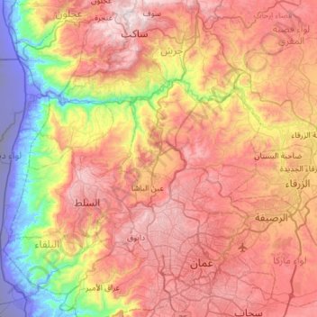
Name: Topografische Karte Zarqa River, Höhe, Relief.
Ort: Zarqa River, Jarash, Jordan (31.98667 35.54332 32.21824 36.08657)
Durchschnittliche Höhe: 584 m
Minimale Höhe: -313 m
Maximale Höhe: 1’246 m
Andere topografische Karten
Klicken Sie auf eine Karte, um ihre Topografie, ihre Höhe und ihr Relief anzuzeigen.
Sakib
Jordan > Jarash > Jerash Sub-District
Sakib is situated on the East Bank Plateau. Originally, the city had been built on Mountains. Sakib's terrain is typified by its mountains, and the area's elevation ranges from 900 to 1,200 m. Jerash is located to the east, Irbid io the north, Zarqa to the southeast and the capital Amman is to Sakib's south.
Durchschnittliche Höhe: 639 m