
Topografische Karte Hatherton
Klicken Sie auf die Karte, um die Höhe anzuzeigen.
Über diese Karte
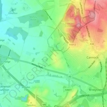
Name: Topografische Karte Hatherton, Höhe, Relief.
Durchschnittliche Höhe: 128 m
Minimale Höhe: 91 m
Maximale Höhe: 198 m
Andere topografische Karten
Klicken Sie auf eine Karte, um ihre Topografie, ihre Höhe und ihr Relief anzuzeigen.
Wombourne
United Kingdom > England > Staffordshire > South Staffordshire
Durchschnittliche Höhe: 106 m
Huntington
United Kingdom > England > Staffordshire > South Staffordshire
Durchschnittliche Höhe: 166 m
Weston Park
United Kingdom > England > Staffordshire > South Staffordshire > Weston under Lizard
Durchschnittliche Höhe: 113 m
Pattingham
United Kingdom > England > Staffordshire > South Staffordshire
Durchschnittliche Höhe: 106 m
Coppenhall
United Kingdom > England > Staffordshire > South Staffordshire
Durchschnittliche Höhe: 104 m
Levedale
United Kingdom > England > Staffordshire > South Staffordshire > Penkridge
Durchschnittliche Höhe: 98 m
Himley
United Kingdom > England > Staffordshire > South Staffordshire > Himley
Durchschnittliche Höhe: 96 m
Bednall
United Kingdom > England > Staffordshire > South Staffordshire > Bednall
Durchschnittliche Höhe: 118 m
Halfpenny Green
United Kingdom > England > Staffordshire > South Staffordshire
Durchschnittliche Höhe: 91 m
Acton Trussell
United Kingdom > England > Staffordshire > South Staffordshire
Durchschnittliche Höhe: 93 m
Calf Heath
United Kingdom > England > Staffordshire > South Staffordshire > Hatherton Junction
Durchschnittliche Höhe: 113 m
Mottey Meadows NNR
United Kingdom > England > Staffordshire > South Staffordshire > Wheaton Aston
Durchschnittliche Höhe: 110 m
Whiston
United Kingdom > England > Staffordshire > South Staffordshire > Penkridge
Durchschnittliche Höhe: 95 m
Lower Penn
United Kingdom > England > Staffordshire > South Staffordshire
Durchschnittliche Höhe: 114 m
Gospel End
United Kingdom > England > Staffordshire > South Staffordshire
Durchschnittliche Höhe: 158 m
Lutley
United Kingdom > England > Staffordshire > South Staffordshire > Enville
Durchschnittliche Höhe: 100 m
Six Ashes
United Kingdom > England > Staffordshire > South Staffordshire > Bobbington
Durchschnittliche Höhe: 125 m
Clay Gates
United Kingdom > England > Staffordshire > South Staffordshire
Durchschnittliche Höhe: 100 m
Crateford
United Kingdom > England > Staffordshire > South Staffordshire
Durchschnittliche Höhe: 100 m
Weston under Lizard
United Kingdom > England > Staffordshire > South Staffordshire
Durchschnittliche Höhe: 111 m
Wheaton Aston
United Kingdom > England > Staffordshire > South Staffordshire
Durchschnittliche Höhe: 106 m
Baggeridge Country Park
United Kingdom > England > Staffordshire > South Staffordshire
Durchschnittliche Höhe: 146 m
Kinver Edge
United Kingdom > England > Staffordshire > South Staffordshire > Kinver
Durchschnittliche Höhe: 95 m
Bishops Wood
United Kingdom > England > Staffordshire > South Staffordshire
Durchschnittliche Höhe: 127 m
Cannock Lake
United Kingdom > England > Staffordshire > South Staffordshire > Huntington
Durchschnittliche Höhe: 149 m
Hatherton Junction
United Kingdom > England > Staffordshire > South Staffordshire
Durchschnittliche Höhe: 112 m
Gospelash
United Kingdom > England > Staffordshire > South Staffordshire > Bobbington
Durchschnittliche Höhe: 91 m
Bishops Wood
United Kingdom > England > Staffordshire > South Staffordshire
Durchschnittliche Höhe: 127 m
Wheaton Aston
United Kingdom > England > Staffordshire > South Staffordshire
Durchschnittliche Höhe: 106 m
Kinver Edge
United Kingdom > England > Staffordshire > South Staffordshire > Kinver
Durchschnittliche Höhe: 95 m