
Topografische Karte Huntington
Klicken Sie auf die Karte, um die Höhe anzuzeigen.
Über diese Karte
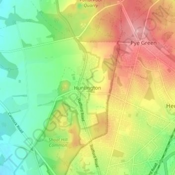
Name: Topografische Karte Huntington, Höhe, Relief.
Durchschnittliche Höhe: 166 m
Minimale Höhe: 107 m
Maximale Höhe: 239 m
Andere topografische Karten
Klicken Sie auf eine Karte, um ihre Topografie, ihre Höhe und ihr Relief anzuzeigen.
Hatherton
United Kingdom > England > Staffordshire > South Staffordshire
Durchschnittliche Höhe: 128 m
Bobbington
United Kingdom > England > Staffordshire > South Staffordshire
Durchschnittliche Höhe: 98 m
Weston Park
United Kingdom > England > Staffordshire > South Staffordshire > Weston under Lizard
Durchschnittliche Höhe: 113 m
Himley
United Kingdom > England > Staffordshire > South Staffordshire > Himley
Durchschnittliche Höhe: 118 m
Great Wyrley
United Kingdom > England > Staffordshire > South Staffordshire
Durchschnittliche Höhe: 138 m
Penkridge
United Kingdom > England > Staffordshire > South Staffordshire
Durchschnittliche Höhe: 106 m
Essington
United Kingdom > England > Staffordshire > South Staffordshire
Durchschnittliche Höhe: 147 m
Featherstone
United Kingdom > England > Staffordshire > South Staffordshire
Durchschnittliche Höhe: 133 m
Cheslyn Hay
United Kingdom > England > Staffordshire > South Staffordshire
Durchschnittliche Höhe: 136 m
Highgate Common
United Kingdom > England > Staffordshire > South Staffordshire > Enville
Durchschnittliche Höhe: 92 m
Mottey Meadows NNR
United Kingdom > England > Staffordshire > South Staffordshire > Wheaton Aston
Durchschnittliche Höhe: 110 m
Lower Penn
United Kingdom > England > Staffordshire > South Staffordshire
Durchschnittliche Höhe: 106 m
Shareshill
United Kingdom > England > Staffordshire > South Staffordshire > Shareshill
Durchschnittliche Höhe: 123 m
Baggeridge Country Park
United Kingdom > England > Staffordshire > South Staffordshire
Durchschnittliche Höhe: 146 m
Wombourne
United Kingdom > England > Staffordshire > South Staffordshire > Wombourne
Durchschnittliche Höhe: 112 m
Cannock Lake
United Kingdom > England > Staffordshire > South Staffordshire > Huntington
Durchschnittliche Höhe: 149 m
Essington
United Kingdom > England > Staffordshire > South Staffordshire
Durchschnittliche Höhe: 147 m