

Topografische Karte Nubra
Klicken Sie auf die Karte, um die Höhe anzuzeigen.
Nubra
The main road access to Nubra is over Khardung La pass which is open throughout the year. The highest elevation of Khardung La is 5,359 m (17,582 ft), its status as the highest motorable road in the world is no longer accepted by most authorities. An alternative route, opened in 2008, crosses the Wari La from Sakti, to the east of Khardung La, connecting to the main Nubra road system via Agham and Khalsar along the Shyok River. There are also trekkable passes over the Ladakh Range from the Indus Valley at various points. Routes from Nubra to Baltistan and Yarkand, though historically important, have been closed since 1947 and 1950 respectively.
Über diese Karte
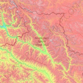
Name: Topografische Karte Nubra, Höhe, Relief.
Ort: Nubra, Leh district, Ladakh, 194401, India (33.97611 76.66317 35.67455 79.04537)
Durchschnittliche Höhe: 4’978 m
Minimale Höhe: 2’471 m
Maximale Höhe: 7’793 m
Andere topografische Karten
Klicken Sie auf eine Karte, um ihre Topografie, ihre Höhe und ihr Relief anzuzeigen.
Dras
Dras (also spelt Drass, ISO transliteration: Drās), also known locally in Shina as Himababs, Hembabs, or Humas, is a town and hill station, near Kargil in the Kargil district of the union territory of Ladakh in India. It is on the NH 1 between Zoji La pass and Kargil. A tourist hub for its high-altitude…
Durchschnittliche Höhe: 3’531 m

Leh
Leh (/ˈlɛ/) (Ladakhi: གླེ) is the joint capital and largest city of Ladakh, a union territory of India. Leh, located in the Leh district, was also the historical capital of the Kingdom of Ladakh, the seat of which was in the Leh Palace, the former residence of the royal family of Ladakh, built in the…
Durchschnittliche Höhe: 4’294 m



Chang La
Chang La is a high mountain pass in Ladakh at an elevation of 5,391.3024 m (17,688.000 ft) in the Ladakh Range between Leh and the Shyok River valley. The Chang La, on Leh to Pangong Lake road, lies on the Leh-Karu-Sakti-Zingral-Chang La-Durbuk-Tangtse-Pangong Lake motorable road. Karu, which lies on…
Durchschnittliche Höhe: 5’464 m


Nyoma
The airbase received the Wildlife Board's forest clearance in 2022 to expand into 508 hectare of land inside Changthang Wildlife Sanctuary. The Government of India announced in January 2023 that this airstrip will be upgraded in two years by the end of 2024 at a cost of Rs.214 crore (US$27 m) to a 1,235 acre…
Durchschnittliche Höhe: 4’260 m

Daulat Beg Oldi
Daulat Beg Oldi (DBO) lies at the northeastern corner of the Karakoram Range, at the northern edge of Depsang Plains at an elevation of 5,100 metres (16,700 ft). The international border with China is 8 km to the north and the Line of Actual Control with Chinese-controlled Aksai Chin is 9 km to the east. Other…
Durchschnittliche Höhe: 5’085 m






Kargil
India > Ladakh > Kargil tehsil
Kargil has an average elevation of 2,676 metres (8,780 feet), and is situated along the banks of the Suru River (Indus). The town of Kargil is located 205 km (127 mi) from Srinagar, facing the Northern Areas across the LOC. Like other areas in the Himalayas, Kargil has a temperate climate. Summers are hot with…
Durchschnittliche Höhe: 3’262 m


Drang Drung Glacier
India > Ladakh > Zanskar tehsil
The Drang-Drung Glacier is likely to be the largest glacier in Ladakh after the Siachen Glacier in the Karakoram Range, with a maximum length of 23 km (14 mi) at an average elevation of 4,780 m (15,680 ft; 2.97 mi). The glacier lies in the northeastern Himalayan Range known as the Zanskar Range, 142 km (88 mi)…
Durchschnittliche Höhe: 5’098 m




Khardung La
India > Ladakh > Leh Tehsil
The elevation of Khardung La is 5,359 m (17,582 ft). Local summit signs and dozens of stores selling shirts in Leh incorrectly claim that its elevation is in the vicinity of 5,602 m (18,379 ft)} and that it is the world's highest motorable pass. But in 2013-2014, Chisumle-Demchok Road via Umling La (19,300…
Durchschnittliche Höhe: 5’235 m


Dah
India > Ladakh > Khalsi tehsil
Traveling up the Dah stream, there are several summer habitations, which the inhabitants of Dha occupy for a short time or longer depending on their elevation. While descending, the first areas to appear are Dunder, Cilgiadi, and Cumavcings, which has cultivated fields. The valley stretching along the Dah…
Durchschnittliche Höhe: 3’301 m


Leh
Leh (/ˈlɛ/) (Ladakhi: གླེ) is the joint capital and largest city of Ladakh, a union territory of India. Leh, located in the Leh district, was also the historical capital of the Kingdom of Ladakh, the seat of which was in the Leh Palace, the former residence of the royal family of Ladakh, built in the…
Durchschnittliche Höhe: 4’294 m





Dras
Dras (also spelt Drass, ISO transliteration: Drās), also known locally in Shina as Himababs, Hembabs, or Humas, is a town and hill station, and the headquarters of Drass district of the union territory of Ladakh in India. It is on the NH 1 between Zoji La pass and Kargil. A tourist hub for its high-altitude…
Durchschnittliche Höhe: 3’531 m
Dras
Dras (also spelt Drass, ISO transliteration: Drās), also known locally as Himababs, Hembabs, or Humas, is a town, hill station and eadquarter of eponymous tehsil and community development block in Drass district of the union territory of Ladakh in India. It is on the NH 1 between Zoji La pass and Kargil town.…
Durchschnittliche Höhe: 3’531 m

Umling La Road highest point
Umling La or Umlung La, elevation 19,024 feet (5,799 m), is a mountain pass in the Changthang area of Ladakh, India near the village of Demchok. It is on the ridgeline that divides Koyul Lungpa and the Indus River at an elevation of 19,024 feet (5,799 m). It forms the source for the Umlung stream that drains…
Durchschnittliche Höhe: 5’717 m
Kargil
India > Ladakh > Kargil tehsil
Kargil has an average elevation of 2,676 m (8,780 ft), and is situated along the banks of the Suru River. The town of Kargil is located 205 km (127 mi) from Srinagar, facing Gilgit-Baltistan across the LoC. Like other areas in the Himalayas, Kargil has a temperate climate. Summers are hot with cool nights,…
Durchschnittliche Höhe: 3’262 m


Nyoma
The upgrade expanded the airstrip to a 1,235 acre an airbase capable of supporting fighter jet operations at 13,700 feet (4,200 m) elevation with an expanded 2.7 km (8,900 ft)-long, 46 m (151 ft)-wide runway paved runway along with allied military infrastructure. The supporting infrastructure included ATC…
Durchschnittliche Höhe: 4’260 m
Nyoma
The upgrade expanded the airstrip to a 1,235 acre an airbase capable of supporting fighter jet operations at 13,700 feet (4,200 m) elevation with an expanded 2.7 km (8,900 ft)-long, 46 m (151 ft)-wide runway paved runway along with allied military infrastructure. The supporting infrastructure included ATC…
Durchschnittliche Höhe: 4’260 m