
Topografische Karte Mayville
Interaktive Karte
Klicken Sie auf die Karte, um die Höhe anzuzeigen.
Über diese Karte
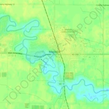
Name: Topografische Karte Mayville, Höhe, Relief.
Ort: Mayville, Traill County, North Dakota, 58257, United States (47.48670 -97.35189 47.50921 -97.30463)
Durchschnittliche Höhe: 296 m
Minimale Höhe: 285 m
Maximale Höhe: 304 m
Andere topografische Karten
Klicken Sie auf eine Karte, um ihre Topografie, ihre Höhe und ihr Relief anzuzeigen.
Hillsboro
United States > North Dakota > Traill County
Hillsboro, Traill County, North Dakota, United States
Durchschnittliche Höhe: 276 m
Portland
United States > North Dakota > Traill County
Portland, Traill County, North Dakota, 58274, United States
Durchschnittliche Höhe: 300 m
Hatton
United States > North Dakota > Traill County
Hatton, Traill County, North Dakota, United States
Durchschnittliche Höhe: 329 m