
Spenden
Rüste dich für dein nächstes Abenteuer:
Als Amazon-Partner verdient diese Seite an qualifizierten Käufen, ohne dass Ihnen zusätzliche Kosten entstehen.
Topografische Karte Great Wyrley
Klicken Sie auf die Karte, um die Höhe anzuzeigen.
Spenden
Rüste dich für dein nächstes Abenteuer:
Als Amazon-Partner verdient diese Seite an qualifizierten Käufen, ohne dass Ihnen zusätzliche Kosten entstehen.
Über diese Karte
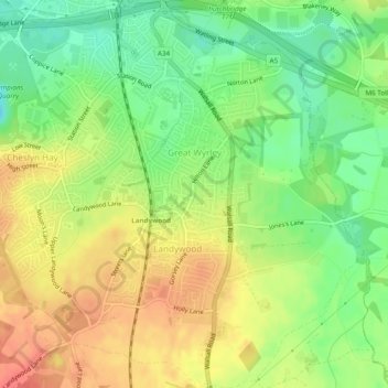
Name: Topografische Karte Great Wyrley, Höhe, Relief.
Durchschnittliche Höhe: 138 m
Minimale Höhe: 110 m
Maximale Höhe: 165 m
Spenden
Rüste dich für dein nächstes Abenteuer:
Als Amazon-Partner verdient diese Seite an qualifizierten Käufen, ohne dass Ihnen zusätzliche Kosten entstehen.
Andere topografische Karten
Klicken Sie auf eine Karte, um ihre Topografie, ihre Höhe und ihr Relief anzuzeigen.
Kinver Edge
United Kingdom > England > Staffordshire > South Staffordshire > Kinver
Durchschnittliche Höhe: 95 m
Wombourne
United Kingdom > England > Staffordshire > South Staffordshire
Durchschnittliche Höhe: 106 m
Huntington
United Kingdom > England > Staffordshire > South Staffordshire
Durchschnittliche Höhe: 166 m
Weston Park
United Kingdom > England > Staffordshire > South Staffordshire > Weston under Lizard
Durchschnittliche Höhe: 113 m
Spenden
Rüste dich für dein nächstes Abenteuer:
Als Amazon-Partner verdient diese Seite an qualifizierten Käufen, ohne dass Ihnen zusätzliche Kosten entstehen.
Pattingham
United Kingdom > England > Staffordshire > South Staffordshire
Durchschnittliche Höhe: 106 m
Coppenhall
United Kingdom > England > Staffordshire > South Staffordshire
Durchschnittliche Höhe: 104 m
Levedale
United Kingdom > England > Staffordshire > South Staffordshire > Penkridge
Durchschnittliche Höhe: 98 m
Spenden
Rüste dich für dein nächstes Abenteuer:
Als Amazon-Partner verdient diese Seite an qualifizierten Käufen, ohne dass Ihnen zusätzliche Kosten entstehen.
Bednall
United Kingdom > England > Staffordshire > South Staffordshire > Bednall
Durchschnittliche Höhe: 118 m
Halfpenny Green
United Kingdom > England > Staffordshire > South Staffordshire
Durchschnittliche Höhe: 91 m
Acton Trussell
United Kingdom > England > Staffordshire > South Staffordshire
Durchschnittliche Höhe: 93 m
Calf Heath
United Kingdom > England > Staffordshire > South Staffordshire > Hatherton Junction
Durchschnittliche Höhe: 113 m
Spenden
Rüste dich für dein nächstes Abenteuer:
Als Amazon-Partner verdient diese Seite an qualifizierten Käufen, ohne dass Ihnen zusätzliche Kosten entstehen.
Mottey Meadows NNR
United Kingdom > England > Staffordshire > South Staffordshire > Wheaton Aston
Durchschnittliche Höhe: 110 m
Whiston
United Kingdom > England > Staffordshire > South Staffordshire > Penkridge
Durchschnittliche Höhe: 95 m
Spenden
Rüste dich für dein nächstes Abenteuer:
Als Amazon-Partner verdient diese Seite an qualifizierten Käufen, ohne dass Ihnen zusätzliche Kosten entstehen.
Lower Penn
United Kingdom > England > Staffordshire > South Staffordshire
Durchschnittliche Höhe: 114 m
Gospel End
United Kingdom > England > Staffordshire > South Staffordshire
Durchschnittliche Höhe: 158 m
Lutley
United Kingdom > England > Staffordshire > South Staffordshire > Enville
Durchschnittliche Höhe: 100 m
Six Ashes
United Kingdom > England > Staffordshire > South Staffordshire > Bobbington
Durchschnittliche Höhe: 125 m
Spenden
Rüste dich für dein nächstes Abenteuer:
Als Amazon-Partner verdient diese Seite an qualifizierten Käufen, ohne dass Ihnen zusätzliche Kosten entstehen.
Clay Gates
United Kingdom > England > Staffordshire > South Staffordshire
Durchschnittliche Höhe: 100 m
Crateford
United Kingdom > England > Staffordshire > South Staffordshire
Durchschnittliche Höhe: 100 m
Weston under Lizard
United Kingdom > England > Staffordshire > South Staffordshire
Durchschnittliche Höhe: 111 m
Wheaton Aston
United Kingdom > England > Staffordshire > South Staffordshire
Durchschnittliche Höhe: 106 m
Spenden
Rüste dich für dein nächstes Abenteuer:
Als Amazon-Partner verdient diese Seite an qualifizierten Käufen, ohne dass Ihnen zusätzliche Kosten entstehen.
Baggeridge Country Park
United Kingdom > England > Staffordshire > South Staffordshire
Durchschnittliche Höhe: 146 m
Hatherton Junction
United Kingdom > England > Staffordshire > South Staffordshire
Durchschnittliche Höhe: 112 m
Spenden
Rüste dich für dein nächstes Abenteuer:
Als Amazon-Partner verdient diese Seite an qualifizierten Käufen, ohne dass Ihnen zusätzliche Kosten entstehen.
Himley
United Kingdom > England > Staffordshire > South Staffordshire > Himley
Durchschnittliche Höhe: 96 m
Cannock Lake
United Kingdom > England > Staffordshire > South Staffordshire > Huntington
Durchschnittliche Höhe: 149 m
Spenden
Rüste dich für dein nächstes Abenteuer:
Als Amazon-Partner verdient diese Seite an qualifizierten Käufen, ohne dass Ihnen zusätzliche Kosten entstehen.
Gospelash
United Kingdom > England > Staffordshire > South Staffordshire > Bobbington
Durchschnittliche Höhe: 91 m