
Topografische Karte Alagna Valsesia
Interaktive Karte
Klicken Sie auf die Karte, um die Höhe anzuzeigen.
Über diese Karte
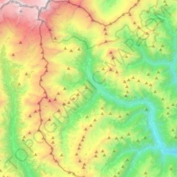
Name: Topografische Karte Alagna Valsesia, Höhe, Relief.
Ort: Alagna Valsesia, Vercelli, Piedmont, 13021, Italy (45.74203 7.86137 45.92738 8.00015)
Durchschnittliche Höhe: 2’071 m
Minimale Höhe: 691 m
Maximale Höhe: 4’528 m
Alagna Valsesia (Walser German: Im Land, Piedmontese: Alagna, Valsesiano: Lagna) is a comune and small village high in the Valsesia alpine valley in the province of Vercelli, Piedmont, northern Italy, a UNESCO World heritage site since 2013. It is a tourist place for mountaineering and winter sports, and it is internationally renowned for the freeride off-piste skiing. It is also the traditional starting point for the Margherita Hut climb, at 4,554 metres (14,941 ft) above sea level, the highest building in Europe. It was originally settled by Walser at the beginning of the 12th century. It is located at an elevation of 1,191 metres (3,907 ft) just south of the Monte Rosa, elevation 4,638 metres (15,217 ft) (the second tallest peak in the Alps); It is very close to Milan (130 kilometres (81 mi)) and to the international Milan–Malpensa Airport (106 kilometres (66 mi)).
Andere topografische Karten
Klicken Sie auf eine Karte, um ihre Topografie, ihre Höhe und ihr Relief anzuzeigen.
San Giuseppe
San Giuseppe, Alto Sermenza, Vercelli, Piedmont, 13029, Italy
Durchschnittliche Höhe: 1’620 m
Moncrivello
Moncrivello, Vercelli, Piedmont, Italy
Durchschnittliche Höhe: 242 m