
Topografische Karte Kicking Horse
Interaktive Karte
Klicken Sie auf die Karte, um die Höhe anzuzeigen.
Über diese Karte
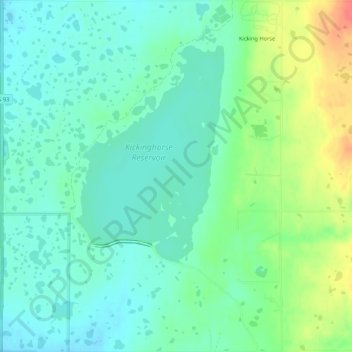
Name: Topografische Karte Kicking Horse, Höhe, Relief.
Ort: Kicking Horse, Lake County, Montana, United States (47.44261 -114.09698 47.47892 -114.05407)
Durchschnittliche Höhe: 938 m
Minimale Höhe: 922 m
Maximale Höhe: 973 m
Andere topografische Karten
Klicken Sie auf eine Karte, um ihre Topografie, ihre Höhe und ihr Relief anzuzeigen.
Charlo
United States > Montana > Lake County
Charlo, Lake County, Montana, United States
Durchschnittliche Höhe: 895 m
Saint Ignatius
United States > Montana > Lake County
Saint Ignatius, Lake County, Montana, 59865, United States
Durchschnittliche Höhe: 893 m
Flathead Lake
United States > Montana > Lake County
Flathead Lake, Lake County, Montana, United States
Durchschnittliche Höhe: 1’168 m
Polson
United States > Montana > Lake County
Polson, Lake County, Montana, United States
Durchschnittliche Höhe: 929 m
North Swan Valley Wildlife Management Area
United States > Montana > Lake County
North Swan Valley Wildlife Management Area, Lake County, Montana, United States
Durchschnittliche Höhe: 1’231 m
Moore Lake
United States > Montana > Lake County
Moore Lake, Lake County, Montana, United States
Durchschnittliche Höhe: 1’806 m
Estes Lake
United States > Montana > Lake County
Estes Lake, Lake County, Montana, United States
Durchschnittliche Höhe: 1’068 m
Big Arm
United States > Montana > Lake County
Big Arm, Lake County, Montana, 59910, United States
Durchschnittliche Höhe: 1’064 m
Mission Valley Historical Marker
United States > Montana > Lake County
Mission Valley Historical Marker, Lake County, Montana, 59865, United States
Durchschnittliche Höhe: 909 m