
Spenden
Rüste dich für dein nächstes Abenteuer:
Als Amazon-Partner verdient diese Seite an qualifizierten Käufen, ohne dass Ihnen zusätzliche Kosten entstehen.
Topografische Karte Lillooet
Klicken Sie auf die Karte, um die Höhe anzuzeigen.
Spenden
Rüste dich für dein nächstes Abenteuer:
Als Amazon-Partner verdient diese Seite an qualifizierten Käufen, ohne dass Ihnen zusätzliche Kosten entstehen.
Über diese Karte
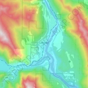
Name: Topografische Karte Lillooet, Höhe, Relief.
Durchschnittliche Höhe: 736 m
Minimale Höhe: 183 m
Maximale Höhe: 1’937 m
Spenden
Rüste dich für dein nächstes Abenteuer:
Als Amazon-Partner verdient diese Seite an qualifizierten Käufen, ohne dass Ihnen zusätzliche Kosten entstehen.
Andere topografische Karten
Klicken Sie auf eine Karte, um ihre Topografie, ihre Höhe und ihr Relief anzuzeigen.
Panorama Ridge
Canada > British Columbia > Squamish-Lillooet Regional District > Area D (Elaho/Garibaldi)
Durchschnittliche Höhe: 1’786 m
Whistler Mountain
Canada > British Columbia > Squamish-Lillooet Regional District > Whistler
There is a weather station near the summit of Whistler Mountain at the Roundhouse Lodge, located at an elevation of 1835 m (6020 ft). Whistler Roundhouse has a dry-summer subalpine climate (Köppen Dsc), bordering on an Alpine climate (Köppen ET).
Durchschnittliche Höhe: 1’810 m
Sentinel Glacier
Canada > British Columbia > Squamish-Lillooet Regional District > Area D (Elaho/Garibaldi)
Durchschnittliche Höhe: 1’856 m
The Table
Canada > British Columbia > Squamish-Lillooet Regional District > Area D (Elaho/Garibaldi)
Durchschnittliche Höhe: 1’623 m
Spenden
Rüste dich für dein nächstes Abenteuer:
Als Amazon-Partner verdient diese Seite an qualifizierten Käufen, ohne dass Ihnen zusätzliche Kosten entstehen.
Exodus Peak
Canada > British Columbia > Squamish-Lillooet Regional District > Area C (Pemberton Valley/Mount Currie/D'Arcy)
Durchschnittliche Höhe: 2’115 m
Whistler
Canada > British Columbia > Squamish-Lillooet Regional District > Whistler Resort Municipality > Whistler
Durchschnittliche Höhe: 996 m
Britannia Beach
Canada > British Columbia > Squamish-Lillooet Regional District > Area D (Elaho/Garibaldi)
Durchschnittliche Höhe: 208 m
Lake La Mare Recreation Site
Canada > British Columbia > Squamish-Lillooet Regional District > Area B (Cayoosh/Pavilion)
Durchschnittliche Höhe: 1’272 m
Spenden
Rüste dich für dein nächstes Abenteuer:
Als Amazon-Partner verdient diese Seite an qualifizierten Käufen, ohne dass Ihnen zusätzliche Kosten entstehen.
Elfin Lakes
Canada > British Columbia > Squamish-Lillooet Regional District > Area D (Elaho/Garibaldi)
Durchschnittliche Höhe: 1’331 m
Cirque Peak
Canada > British Columbia > Squamish-Lillooet Regional District > Area C (Pemberton Valley/Mount Currie/D'Arcy)
Durchschnittliche Höhe: 1’999 m
Bralorne
Canada > British Columbia > Squamish-Lillooet Regional District > Area A (Upper Bridge River Valley)
Durchschnittliche Höhe: 1’255 m
Cheekye River
Canada > British Columbia > Squamish-Lillooet Regional District > Area D (Elaho/Garibaldi)
Durchschnittliche Höhe: 634 m
Spenden
Rüste dich für dein nächstes Abenteuer:
Als Amazon-Partner verdient diese Seite an qualifizierten Käufen, ohne dass Ihnen zusätzliche Kosten entstehen.
The Black Tusk
Canada > British Columbia > Squamish-Lillooet Regional District > Area D (Elaho/Garibaldi)
Durchschnittliche Höhe: 1’874 m
Spruce Lake
Canada > British Columbia > Squamish-Lillooet Regional District > Area A (Upper Bridge River Valley)
Durchschnittliche Höhe: 1’688 m
Brandywine
Canada > British Columbia > Squamish-Lillooet Regional District > Area D (Elaho/Garibaldi)
Durchschnittliche Höhe: 515 m
The Black Tusk (True Summit)
Canada > British Columbia > Squamish-Lillooet Regional District > Area D (Elaho/Garibaldi)
Durchschnittliche Höhe: 1’875 m
Spenden
Rüste dich für dein nächstes Abenteuer:
Als Amazon-Partner verdient diese Seite an qualifizierten Käufen, ohne dass Ihnen zusätzliche Kosten entstehen.
D'Arcy
Canada > British Columbia > Squamish-Lillooet Regional District > Area C (Pemberton Valley/Mount Currie/D'Arcy)
Durchschnittliche Höhe: 461 m
Slhanay
Canada > British Columbia > Squamish-Lillooet Regional District > Area D (Elaho/Garibaldi)
Durchschnittliche Höhe: 363 m
Edith Lake
Canada > British Columbia > Squamish-Lillooet Regional District > Squamish
Durchschnittliche Höhe: 309 m
Alice Lake
Canada > British Columbia > Squamish-Lillooet Regional District > Squamish
Durchschnittliche Höhe: 247 m
Spenden
Rüste dich für dein nächstes Abenteuer:
Als Amazon-Partner verdient diese Seite an qualifizierten Käufen, ohne dass Ihnen zusätzliche Kosten entstehen.
Birken
Canada > British Columbia > Squamish-Lillooet Regional District > Area C (Pemberton Valley/Mount Currie/D'Arcy)
Durchschnittliche Höhe: 796 m
Mount Sproatt
Canada > British Columbia > Squamish-Lillooet Regional District > Whistler
Durchschnittliche Höhe: 1’533 m
Mount Price
Canada > British Columbia > Squamish-Lillooet Regional District > Area D (Elaho/Garibaldi)
Mount Price is a small stratovolcano in the Garibaldi Ranges of the Pacific Ranges in southwestern British Columbia, Canada. It has an elevation of 2,049 metres (6,722 feet) and rises above the surrounding landscape on the western side of Garibaldi Lake in New Westminster Land District. The mountain contains a…
Durchschnittliche Höhe: 1’672 m
Moha
Canada > British Columbia > Squamish-Lillooet Regional District > Area B (Cayoosh/Pavilion)
Durchschnittliche Höhe: 706 m
Spenden
Rüste dich für dein nächstes Abenteuer:
Als Amazon-Partner verdient diese Seite an qualifizierten Käufen, ohne dass Ihnen zusätzliche Kosten entstehen.
Barrier Lake
Canada > British Columbia > Squamish-Lillooet Regional District > Area D (Elaho/Garibaldi)
Durchschnittliche Höhe: 1’405 m
Pemberton Meadows
Canada > British Columbia > Squamish-Lillooet Regional District > Area C (Pemberton Valley/Mount Currie/D'Arcy) > Pemberton Meadows
Durchschnittliche Höhe: 480 m
Whistler Village
Canada > British Columbia > Squamish-Lillooet Regional District > Whistler
Durchschnittliche Höhe: 775 m
Furry Creek
Canada > British Columbia > Squamish-Lillooet Regional District > Area D (Elaho/Garibaldi)
Durchschnittliche Höhe: 224 m
Spenden
Rüste dich für dein nächstes Abenteuer:
Als Amazon-Partner verdient diese Seite an qualifizierten Käufen, ohne dass Ihnen zusätzliche Kosten entstehen.
Cheakamus River
Canada > British Columbia > Squamish-Lillooet Regional District > Squamish
Durchschnittliche Höhe: 266 m
Deeks Lake
Canada > British Columbia > Squamish-Lillooet Regional District > Area D (Elaho/Garibaldi)
Durchschnittliche Höhe: 1’237 m
Garibaldi
Canada > British Columbia > Squamish-Lillooet Regional District > Area D (Elaho/Garibaldi)
Durchschnittliche Höhe: 417 m
Brexton
Canada > British Columbia > Squamish-Lillooet Regional District > Area A (Upper Bridge River Valley)
Durchschnittliche Höhe: 975 m
Spenden
Rüste dich für dein nächstes Abenteuer:
Als Amazon-Partner verdient diese Seite an qualifizierten Käufen, ohne dass Ihnen zusätzliche Kosten entstehen.
Chipmunk Mountain West Peak
Canada > British Columbia > Squamish-Lillooet Regional District > Area A (Upper Bridge River Valley)
Durchschnittliche Höhe: 1’964 m
Mount Aragorn
Canada > British Columbia > Squamish-Lillooet Regional District > Area A (Upper Bridge River Valley)
Durchschnittliche Höhe: 2’115 m
Minaty Bay
Canada > British Columbia > Squamish-Lillooet Regional District > Area D (Elaho/Garibaldi)
Durchschnittliche Höhe: 91 m
Mount Brew
Canada > British Columbia > Squamish-Lillooet Regional District > Area D (Elaho/Garibaldi)
Durchschnittliche Höhe: 1’513 m
Spenden
Rüste dich für dein nächstes Abenteuer:
Als Amazon-Partner verdient diese Seite an qualifizierten Käufen, ohne dass Ihnen zusätzliche Kosten entstehen.
Nairn Falls
Canada > British Columbia > Squamish-Lillooet Regional District > Area C (Pemberton Valley/Mount Currie/D'Arcy)
Durchschnittliche Höhe: 545 m
Gun Creek
Canada > British Columbia > Squamish-Lillooet Regional District > Area A (Upper Bridge River Valley)
Durchschnittliche Höhe: 1’373 m
Onion Peak
Canada > British Columbia > Squamish-Lillooet Regional District > Area B (Cayoosh/Pavilion)
Durchschnittliche Höhe: 2’263 m
Metal Dome
Canada > British Columbia > Squamish-Lillooet Regional District > Area D (Elaho/Garibaldi)
Durchschnittliche Höhe: 1’678 m
Spenden
Rüste dich für dein nächstes Abenteuer:
Als Amazon-Partner verdient diese Seite an qualifizierten Käufen, ohne dass Ihnen zusätzliche Kosten entstehen.
Seton Portage
Canada > British Columbia > Squamish-Lillooet Regional District > Area B (Cayoosh/Pavilion)
Durchschnittliche Höhe: 523 m
Mount Fergusson
Canada > British Columbia > Squamish-Lillooet Regional District > Area A (Upper Bridge River Valley)
Durchschnittliche Höhe: 2’156 m
Mount Sloan
Canada > British Columbia > Squamish-Lillooet Regional District > Area A (Upper Bridge River Valley)
Durchschnittliche Höhe: 2’089 m
Marble Canyon
Canada > British Columbia > Squamish-Lillooet Regional District > Area B (Cayoosh/Pavilion)
Durchschnittliche Höhe: 1’141 m
Spenden
Rüste dich für dein nächstes Abenteuer:
Als Amazon-Partner verdient diese Seite an qualifizierten Käufen, ohne dass Ihnen zusätzliche Kosten entstehen.
Gin Peak
Canada > British Columbia > Squamish-Lillooet Regional District > Area C (Pemberton Valley/Mount Currie/D'Arcy)
Durchschnittliche Höhe: 1’518 m
Locomotive Mountain
Canada > British Columbia > Squamish-Lillooet Regional District > Area C (Pemberton Valley/Mount Currie/D'Arcy)
Durchschnittliche Höhe: 1’951 m
Gold Bridge
Canada > British Columbia > Squamish-Lillooet Regional District > Area A (Upper Bridge River Valley)
Durchschnittliche Höhe: 886 m
Mount Meager
Canada > British Columbia > Squamish-Lillooet Regional District > Area C (Pemberton Valley/Mount Currie/D'Arcy)
Durchschnittliche Höhe: 2’110 m
Spenden
Rüste dich für dein nächstes Abenteuer:
Als Amazon-Partner verdient diese Seite an qualifizierten Käufen, ohne dass Ihnen zusätzliche Kosten entstehen.
Whistler Olympic Park
Canada > British Columbia > Squamish-Lillooet Regional District > Area D (Elaho/Garibaldi)
Durchschnittliche Höhe: 954 m
Wedgemount Falls
Canada > British Columbia > Squamish-Lillooet Regional District > Area C (Pemberton Valley/Mount Currie/D'Arcy)
Durchschnittliche Höhe: 1’913 m
Mount Rohr
Canada > British Columbia > Squamish-Lillooet Regional District > Area B (Cayoosh/Pavilion)
Durchschnittliche Höhe: 1’940 m
Sunshine Mountain
Canada > British Columbia > Squamish-Lillooet Regional District > Area A (Upper Bridge River Valley)
Durchschnittliche Höhe: 1’965 m
Spenden
Rüste dich für dein nächstes Abenteuer:
Als Amazon-Partner verdient diese Seite an qualifizierten Käufen, ohne dass Ihnen zusätzliche Kosten entstehen.
Mount Cayley
Canada > British Columbia > Squamish-Lillooet Regional District > Area D (Elaho/Garibaldi)
Mount Cayley is an eroded but potentially active stratovolcano in the Pacific Ranges of southwestern British Columbia, Canada. Located 45 km (28 mi) north of Squamish and 24 km (15 mi) west of Whistler, the volcano resides on the edge of the Powder Mountain Icefield. It consists of massif that towers over the…
Durchschnittliche Höhe: 1’896 m
Helm Glacier
Canada > British Columbia > Squamish-Lillooet Regional District > Area D (Elaho/Garibaldi)
Durchschnittliche Höhe: 1’949 m
Mount Fee
Canada > British Columbia > Squamish-Lillooet Regional District > Area D (Elaho/Garibaldi)
Mount Fee is a volcanic peak in the Pacific Ranges of the Coast Mountains in southwestern British Columbia, Canada. It is located 13 km (8.1 mi) south of Callaghan Lake and 21 km (13 mi) west of the resort town of Whistler. With a summit elevation of 2,162 m (7,093 ft) and a topographic prominence of 312 m…
Durchschnittliche Höhe: 1’771 m
Mount Callaghan
Canada > British Columbia > Squamish-Lillooet Regional District > Area C (Pemberton Valley/Mount Currie/D'Arcy)
Durchschnittliche Höhe: 2’076 m
Spenden
Rüste dich für dein nächstes Abenteuer:
Als Amazon-Partner verdient diese Seite an qualifizierten Käufen, ohne dass Ihnen zusätzliche Kosten entstehen.
Ring Mountain
Canada > British Columbia > Squamish-Lillooet Regional District > Area D (Elaho/Garibaldi)
Durchschnittliche Höhe: 1’816 m
Chimney Rock
Canada > British Columbia > Squamish-Lillooet Regional District > Area B (Cayoosh/Pavilion)
Durchschnittliche Höhe: 1’506 m
Aussichtspunkt auf Lilloet und Fluss
Canada > British Columbia > Squamish-Lillooet Regional District > Lillooet
Durchschnittliche Höhe: 510 m
Tonic Peak
Canada > British Columbia > Squamish-Lillooet Regional District > Whistler Resort Municipality
Durchschnittliche Höhe: 1’586 m
Spenden
Rüste dich für dein nächstes Abenteuer:
Als Amazon-Partner verdient diese Seite an qualifizierten Käufen, ohne dass Ihnen zusätzliche Kosten entstehen.
Whistler Village
Canada > British Columbia > Squamish-Lillooet Regional District > Whistler
Durchschnittliche Höhe: 775 m
Whistler Mountain
Canada > British Columbia > Squamish-Lillooet Regional District > Whistler
There is a weather station near the summit of Whistler Mountain at the Roundhouse Lodge, located at an elevation of 1835 m (6020 ft). Whistler Roundhouse has a dry-summer subalpine climate (Köppen Dsc), bordering on an Alpine climate (Köppen ET).
Durchschnittliche Höhe: 1’810 m
Mount Currie
Canada > British Columbia > Squamish-Lillooet Regional District > Area C (Pemberton Valley/Mount Currie/D'Arcy)
Durchschnittliche Höhe: 2’107 m
Beacon Mountain
Canada > British Columbia > Squamish-Lillooet Regional District > Area C (Pemberton Valley/Mount Currie/D'Arcy)
Durchschnittliche Höhe: 1’496 m
Spenden
Rüste dich für dein nächstes Abenteuer:
Als Amazon-Partner verdient diese Seite an qualifizierten Käufen, ohne dass Ihnen zusätzliche Kosten entstehen.
Watts Point
Canada > British Columbia > Squamish-Lillooet Regional District > Squamish
Durchschnittliche Höhe: 44 m
Furry Creek
Canada > British Columbia > Squamish-Lillooet Regional District > Area D (Elaho/Garibaldi)
Durchschnittliche Höhe: 224 m
The Galapagos Islands Boulder
Canada > British Columbia > Squamish-Lillooet Regional District > Squamish
Durchschnittliche Höhe: 289 m
Mount Rohr
Canada > British Columbia > Squamish-Lillooet Regional District > Area B (Cayoosh/Pavilion)
Durchschnittliche Höhe: 1’940 m
Spenden
Rüste dich für dein nächstes Abenteuer:
Als Amazon-Partner verdient diese Seite an qualifizierten Käufen, ohne dass Ihnen zusätzliche Kosten entstehen.
Little Big Horn
Canada > British Columbia > Squamish-Lillooet Regional District > Area A (Upper Bridge River Valley)
Durchschnittliche Höhe: 1’986 m
Mount Meager
Canada > British Columbia > Squamish-Lillooet Regional District > Area C (Pemberton Valley/Mount Currie/D'Arcy)
Durchschnittliche Höhe: 2’110 m
Soprano Peak
Canada > British Columbia > Squamish-Lillooet Regional District > Area B (Cayoosh/Pavilion)
Durchschnittliche Höhe: 2’137 m
Furry Creek
Canada > British Columbia > Squamish-Lillooet Regional District > Area D (Elaho/Garibaldi)
Durchschnittliche Höhe: 224 m
Spenden
Rüste dich für dein nächstes Abenteuer:
Als Amazon-Partner verdient diese Seite an qualifizierten Käufen, ohne dass Ihnen zusätzliche Kosten entstehen.
Ring Mountain
Canada > British Columbia > Squamish-Lillooet Regional District > Area D (Elaho/Garibaldi)
Durchschnittliche Höhe: 1’816 m
Mt. Mulligan
Canada > British Columbia > Squamish-Lillooet Regional District > Area D (Elaho/Garibaldi)
Durchschnittliche Höhe: 1’159 m
Lost Peak
Canada > British Columbia > Squamish-Lillooet Regional District > Area B (Cayoosh/Pavilion)
Durchschnittliche Höhe: 2’176 m
The Table
Canada > British Columbia > Squamish-Lillooet Regional District > Area D (Elaho/Garibaldi)
Durchschnittliche Höhe: 1’623 m
Spenden
Rüste dich für dein nächstes Abenteuer:
Als Amazon-Partner verdient diese Seite an qualifizierten Käufen, ohne dass Ihnen zusätzliche Kosten entstehen.
Beach Mountain
Canada > British Columbia > Squamish-Lillooet Regional District > Area C (Pemberton Valley/Mount Currie/D'Arcy)
Durchschnittliche Höhe: 2’063 m
The Copilot
Canada > British Columbia > Squamish-Lillooet Regional District > Area D (Elaho/Garibaldi)
Durchschnittliche Höhe: 1’466 m
Mount Meager
Canada > British Columbia > Squamish-Lillooet Regional District > Area C (Pemberton Valley/Mount Currie/D'Arcy)
Durchschnittliche Höhe: 2’110 m
The Galapagos Islands Boulder
Canada > British Columbia > Squamish-Lillooet Regional District > Squamish
Durchschnittliche Höhe: 289 m
Spenden
Rüste dich für dein nächstes Abenteuer:
Als Amazon-Partner verdient diese Seite an qualifizierten Käufen, ohne dass Ihnen zusätzliche Kosten entstehen.
Whistler Village
Canada > British Columbia > Squamish-Lillooet Regional District > Whistler
Durchschnittliche Höhe: 775 m